Canopy-height profiles and harvest-edge distance bins in HJ Andrews' unharvested forest (Bell, Spies & Pabst 2017)
From open HJ Andrews layers and all 122 LiDAR tiles over the study area, 38,333 pixels of unharvested forest fall in the paper's three harvest-edge distance bins (published 37,900), split 11.2%, 10.7% and 78.1% (published 10.6%, 11.0% and 78.4%). The canopy-height profiles come from NativeGIS; the PCA on them, computed outside NativeGIS, puts 91.5% of the variance on four axes on the covariance matrix and 72.4% on the correlation matrix, either side of the published 85.2%.
- 15–45 m from a harvest10.6% → 11.16% +0.6 ptswithin tolerance
- 45–75 m from a harvest11.0% → 10.69% −0.3 ptswithin tolerance
- More than 75 m from a harvest78.4% → 78.15% −0.3 ptswithin tolerance
- 30 m pixels in the three bins≈ 37,900 pixels → 38,333.0 pixels +433.0 pixels (+1.1%)within tolerance
[53, 55]
[53, 55, 57]
Numbers in brackets, like [14], are step numbers in this study's run.json: the NativeGIS call that returned the figure. NativeGIS 0.4.0, recorded 2026-10-31 22:02 UTC.
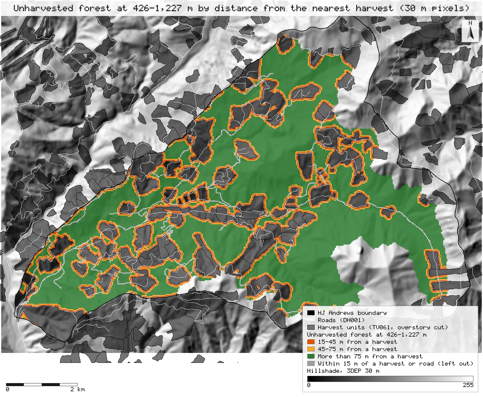
Click or tap a map to open it full screen, then zoom and pan.
What was published
The paper maps the edge influence of past clearcutting on the old forest left standing at HJ Andrews. It describes each 30 m pixel of unharvested forest at 426–1,227 m by its canopy-height profile, "the proportion of the total lidar returns for each 5-m height bin" from the August 2008 LiDAR, and runs a principal component analysis on the profiles of all unharvested pixels: the first four axes explain 85.2% of the variation. It then groups pixels by distance from the nearest harvest: 10.6% of the unharvested forest lies 15–45 m from a harvest, 11.0% lies 45–75 m away and 78.4% further (the abstract rounds the first two to 20% within 75 m), over 37,900 pixels. Harvest patches are 0.2 to 119.0 ha and 13 to 60 years old; the 2008 LiDAR averaged 9 returns per m², about 8,100 per pixel. The discussion adds that roughly 60% of the forest between 400 and 1,100 m remains uncut.
Bell et al. 2017 (journal) · Bell et al. 2017 (Forest Service full text) · HJ Andrews publication record · HJ Andrews data catalogue
Published method. Pixels within 15 m of a harvest or a road are left out of the distance analysis. Harvest boundaries are the historical harvest maps retraced on the 2008 LiDAR's 95th-percentile height (Zald et al. 2016). The paper does not say whether the PCA used the covariance or the correlation matrix, how the height bins treat ground returns beyond "bare-earth returns (<5 m)", or which DEM set the elevation limits. The basal-area models (102 field plots) and the edge-influence estimates built on them need plot data that is not shared, so they are not reproduced here.
The data and where it came from
All of it is open: downloaded without an account or a form.
| Data | Where | Licence |
|---|---|---|
| Vegetation with the 2008 LiDAR harvest units (TV061, hja_veg2008.shp): the Willamette National Forest stand map with cutting-unit boundaries redrawn on the 2008 LiDAR ("Harald Zald created the harvest layer"); every polygon with an overstory cut year (OVRSTRY_YR > 0) is a harvest | HJ Andrews LTER, zip, no form or account https://andrewsforest.oregonstate.edu/sites/default/files/lter/data/studies/spatialdata/tv06101.zip | HJ Andrews data policy (CC BY, acknowledgement requested) |
| Road construction history 1952–1990 (DH001, roads_history.shp) | HJ Andrews LTER, zip, no form or account https://andrewsforest.oregonstate.edu/sites/default/files/lter/data/studies/spatialdata/dh00101.zip | HJ Andrews data policy (CC BY, acknowledgement requested) |
| HJ Andrews Experimental Forest boundary (GI006, boundary83.shp) | HJ Andrews LTER, zip, no form or account https://andrewsforest.oregonstate.edu/sites/default/files/lter/data/studies/spatialdata/gi00601.zip | HJ Andrews data policy (CC BY, acknowledgement requested) |
| USGS 3DEP elevation, exported at 30 m (32-bit float GeoTIFF, EPSG:26910) on the 30 m lattice the LiDAR metrics use | USGS National Map 3DEP elevation image service (exportImage), no form or account https://elevation.nationalmap.gov/arcgis/rest/services/3DEPElevation/ImageServer | US federal data, public domain |
| The 2008 LiDAR flight the paper used (Watershed Sciences, August 2008): the 122 tiles of 750 × 750 m that meet the study area, EPSG:26910 | OpenTopography OTLAS.082011.26910.1, anonymous bulk download (4.0 GB) https://portal.opentopography.org/lidarDataset?opentopoID=OTLAS.082011.26910.1 | Treated as CC BY 4.0 with attribution to HJ Andrews / Watershed Sciences (HJ Andrews catalogue GI010); OpenTopography lists the licence as not provided |
| The flight's tile index (HJAnd_OR_TileIndex.shp) | OpenTopography, same bulk folder https://opentopography.s3.sdsc.edu/pc-bulk/HJAnd_OR/HJAnd_OR_TileIndex.zip | As the LiDAR |
The input files the run read, pinned by checksum
| File (relative to the data folder) | Bytes | sha256 |
|---|---|---|
samples/hja-open/gi00601/x/boundary83.shp | 10,540 | 0774de0a9ebd9693… |
samples/hja-open/tv06101/x/hja_veg2008.shp | 3,098,488 | ef83a267c95a7d1f… |
samples/hja-open/dh00101/x/roads_history.shp | 384,572 | 738e501d8e90e953… |
samples/dem3dep/hja_26910_30m.tif | 787,706 | 942aafed4bd219be… |
samples/ot2008idx/x/HJAnd_OR_TileIndex.shp | 25,804 | 9cdba01734e369e3… |
samples/ot2008/ot_HJ_Andrews_bin_016.laz | 5,297,335 | ea83e8acd13f15cc… |
samples/ot2008/ot_HJ_Andrews_bin_017.laz | 13,774,825 | 77d03be8a6ac48b7… |
samples/ot2008/ot_HJ_Andrews_bin_018.laz | 26,028,999 | 2bd8602e73218c4c… |
samples/ot2008/ot_HJ_Andrews_bin_020.laz | 17,705,762 | 0a16f821c7772374… |
samples/ot2008/ot_HJ_Andrews_bin_021.laz | 25,410,321 | c4b3e0c016920087… |
samples/ot2008/ot_HJ_Andrews_bin_022.laz | 35,570,792 | c4092a781e548310… |
samples/ot2008/ot_HJ_Andrews_bin_023.laz | 24,070,934 | ec29fe14cc9440fe… |
samples/ot2008/ot_HJ_Andrews_bin_024.laz | 3,125,709 | bb2a56c7a0e779b8… |
samples/ot2008/ot_HJ_Andrews_bin_025.laz | 29,630,326 | c0cd5094fb606379… |
samples/ot2008/ot_HJ_Andrews_bin_026.laz | 31,440,794 | 386ae81bcaeed9ed… |
samples/ot2008/ot_HJ_Andrews_bin_027.laz | 36,117,916 | 3be0b819f4088042… |
samples/ot2008/ot_HJ_Andrews_bin_028.laz | 33,570,105 | a5052ada4e859f87… |
samples/ot2008/ot_HJ_Andrews_bin_029.laz | 24,955,073 | fdfda3f607e0b651… |
samples/ot2008/ot_HJ_Andrews_bin_030.laz | 2,097,847 | 2634d56abeb787d2… |
samples/ot2008/ot_HJ_Andrews_bin_031.laz | 28,341,923 | 1cdced437b83b67f… |
samples/ot2008/ot_HJ_Andrews_bin_032.laz | 33,724,880 | 4b7f7fff312b8706… |
samples/ot2008/ot_HJ_Andrews_bin_033.laz | 34,450,824 | d1886f1d2471d770… |
samples/ot2008/ot_HJ_Andrews_bin_034.laz | 30,627,470 | 48f59b34730446cd… |
samples/ot2008/ot_HJ_Andrews_bin_035.laz | 34,229,195 | 757033b956625886… |
samples/ot2008/ot_HJ_Andrews_bin_036.laz | 9,558,700 | 5cf17f2744e06f0b… |
samples/ot2008/ot_HJ_Andrews_bin_037.laz | 34,294,693 | 775c07810ffd131c… |
samples/ot2008/ot_HJ_Andrews_bin_038.laz | 40,031,403 | 52950a3d9a99594b… |
samples/ot2008/ot_HJ_Andrews_bin_039.laz | 27,163,073 | 8b14913fcf9010d4… |
samples/ot2008/ot_HJ_Andrews_bin_040.laz | 51,443,721 | 1eefedf6bcc7a4e4… |
samples/ot2008/ot_HJ_Andrews_bin_041.laz | 21,161,676 | 5ed6abad1a81a136… |
samples/ot2008/ot_HJ_Andrews_bin_042.laz | 10,610,040 | 6bb526c7032d7066… |
samples/ot2008/ot_HJ_Andrews_bin_043.laz | 25,700,149 | d6b09ac885204b1b… |
samples/ot2008/ot_HJ_Andrews_bin_044.laz | 35,182,734 | 55ad5f4c50538716… |
samples/ot2008/ot_HJ_Andrews_bin_045.laz | 34,637,175 | ed3c4bfdbcf338d2… |
samples/ot2008/ot_HJ_Andrews_bin_046.laz | 31,548,627 | ddfcaf5fa101af75… |
samples/ot2008/ot_HJ_Andrews_bin_047.laz | 46,235,514 | 055891ce1e0ff533… |
samples/ot2008/ot_HJ_Andrews_bin_051.laz | 13,826,800 | e06d376701749a3a… |
samples/ot2008/ot_HJ_Andrews_bin_052.laz | 30,724,723 | 10d95f004101d439… |
samples/ot2008/ot_HJ_Andrews_bin_053.laz | 36,681,040 | ba1658c91d4012cf… |
samples/ot2008/ot_HJ_Andrews_bin_054.laz | 37,364,217 | fd78d0fd9171b8da… |
samples/ot2008/ot_HJ_Andrews_bin_055.laz | 29,479,856 | 60755509a05770dd… |
samples/ot2008/ot_HJ_Andrews_bin_056.laz | 54,201,834 | cfe10b215ee71b11… |
samples/ot2008/ot_HJ_Andrews_bin_057.laz | 32,215,988 | bb42bd054c893038… |
samples/ot2008/ot_HJ_Andrews_bin_062.laz | 41,733,475 | 54e0e22bb4e9e2f9… |
samples/ot2008/ot_HJ_Andrews_bin_063.laz | 35,859,250 | af3a75a5de1b5fe7… |
samples/ot2008/ot_HJ_Andrews_bin_064.laz | 35,770,280 | dd1cf1404f633c95… |
samples/ot2008/ot_HJ_Andrews_bin_065.laz | 30,820,787 | 03b1f67ce2d9e976… |
samples/ot2008/ot_HJ_Andrews_bin_066.laz | 52,184,721 | cc419082524c0e49… |
samples/ot2008/ot_HJ_Andrews_bin_067.laz | 33,994,299 | 6022517b56742ef1… |
samples/ot2008/ot_HJ_Andrews_bin_068.laz | 27,356,468 | 3e35397be2699c2e… |
samples/ot2008/ot_HJ_Andrews_bin_069.laz | 11,568,376 | f7bbd33faadc2989… |
samples/ot2008/ot_HJ_Andrews_bin_077.laz | 44,502,661 | 33d3664cff8f5761… |
samples/ot2008/ot_HJ_Andrews_bin_078.laz | 34,664,791 | 445137c764b38653… |
samples/ot2008/ot_HJ_Andrews_bin_079.laz | 30,167,254 | 92a1e0b5a89c15e1… |
samples/ot2008/ot_HJ_Andrews_bin_080.laz | 30,038,435 | 5c44aec9102b7644… |
samples/ot2008/ot_HJ_Andrews_bin_081.laz | 35,587,325 | f5de0d0322cbde0a… |
samples/ot2008/ot_HJ_Andrews_bin_082.laz | 43,952,536 | feecf36c88ae84cb… |
samples/ot2008/ot_HJ_Andrews_bin_083.laz | 28,021,490 | dc2d04f164070e04… |
samples/ot2008/ot_HJ_Andrews_bin_084.laz | 22,905,724 | 8bbe4f57a5828f17… |
samples/ot2008/ot_HJ_Andrews_bin_085.laz | 21,082,187 | 7b94214e654aa971… |
samples/ot2008/ot_HJ_Andrews_bin_093.laz | 28,847,483 | 6e048f0b5eb0252c… |
samples/ot2008/ot_HJ_Andrews_bin_094.laz | 47,563,218 | 3e2c5f8496494a45… |
samples/ot2008/ot_HJ_Andrews_bin_095.laz | 26,370,801 | c4579c8de0585cb7… |
samples/ot2008/ot_HJ_Andrews_bin_096.laz | 26,165,599 | 238d57d4d1af3255… |
samples/ot2008/ot_HJ_Andrews_bin_097.laz | 32,490,975 | 4077017d8bb78265… |
samples/ot2008/ot_HJ_Andrews_bin_098.laz | 36,932,184 | 3c043be9a3ae345e… |
samples/ot2008/ot_HJ_Andrews_bin_099.laz | 50,987,674 | ba174e26788a0994… |
samples/ot2008/ot_HJ_Andrews_bin_100.laz | 27,093,103 | bf81fa07ed8a166e… |
samples/ot2008/ot_HJ_Andrews_bin_101.laz | 26,872,568 | d8ec521f94a1292f… |
samples/ot2008/ot_HJ_Andrews_bin_102.laz | 18,991,721 | 37668f5b7d39d8af… |
samples/ot2008/ot_HJ_Andrews_bin_107.laz | 29,606,775 | 8c9722360661af21… |
samples/ot2008/ot_HJ_Andrews_bin_108.laz | 40,467,228 | 873e6e07bc71c564… |
samples/ot2008/ot_HJ_Andrews_bin_109.laz | 29,657,569 | 827513295f5856b3… |
samples/ot2008/ot_HJ_Andrews_bin_110.laz | 24,612,702 | f39e9fab0e97f5dc… |
samples/ot2008/ot_HJ_Andrews_bin_111.laz | 36,538,988 | 6977e111b3d8a8f5… |
samples/ot2008/ot_HJ_Andrews_bin_112.laz | 39,085,402 | 757b81d3a5f41a0b… |
samples/ot2008/ot_HJ_Andrews_bin_113.laz | 57,416,874 | a31352128813617f… |
samples/ot2008/ot_HJ_Andrews_bin_114.laz | 32,087,672 | a529e141a30aa97c… |
samples/ot2008/ot_HJ_Andrews_bin_115.laz | 28,751,234 | 71ba6ccaf15187c8… |
samples/ot2008/ot_HJ_Andrews_bin_116.laz | 33,319,471 | c2231aca5d42980e… |
samples/ot2008/ot_HJ_Andrews_bin_119.laz | 30,070,830 | 79c77b939e7dd779… |
samples/ot2008/ot_HJ_Andrews_bin_120.laz | 40,314,000 | 9a753c36a2409ca5… |
samples/ot2008/ot_HJ_Andrews_bin_121.laz | 42,539,606 | daa3773fab920949… |
samples/ot2008/ot_HJ_Andrews_bin_122.laz | 28,427,550 | 1174a08d7c090470… |
samples/ot2008/ot_HJ_Andrews_bin_123.laz | 36,974,672 | 9af333fefc8d56d1… |
samples/ot2008/ot_HJ_Andrews_bin_124.laz | 28,482,571 | c8206a4e2662edea… |
samples/ot2008/ot_HJ_Andrews_bin_125.laz | 42,496,128 | b8fa33bf4433d85d… |
samples/ot2008/ot_HJ_Andrews_bin_126.laz | 47,773,977 | 06e4dc817f05b1c7… |
samples/ot2008/ot_HJ_Andrews_bin_127.laz | 34,168,609 | c557e0ff24e80e74… |
samples/ot2008/ot_HJ_Andrews_bin_128.laz | 32,410,439 | 6d5ce43f7ec35eed… |
samples/ot2008/ot_HJ_Andrews_bin_129.laz | 26,953,870 | 099cfff3037a396e… |
samples/ot2008/ot_HJ_Andrews_bin_133.laz | 37,047,483 | 295b113e3701b352… |
samples/ot2008/ot_HJ_Andrews_bin_134.laz | 34,724,908 | ebbf0a29c6534595… |
samples/ot2008/ot_HJ_Andrews_bin_135.laz | 56,194,427 | 1e5dcf74532d2620… |
samples/ot2008/ot_HJ_Andrews_bin_136.laz | 31,573,048 | b666e41d3daf2ead… |
samples/ot2008/ot_HJ_Andrews_bin_137.laz | 33,493,043 | 7e4abbc3f2d83574… |
samples/ot2008/ot_HJ_Andrews_bin_138.laz | 37,440,969 | be94f27874ac18c5… |
samples/ot2008/ot_HJ_Andrews_bin_139.laz | 31,347,152 | d7876bb5959e49db… |
samples/ot2008/ot_HJ_Andrews_bin_140.laz | 53,240,154 | 67ed473f08433b7f… |
samples/ot2008/ot_HJ_Andrews_bin_141.laz | 30,681,674 | 1bf86a19473fcf05… |
samples/ot2008/ot_HJ_Andrews_bin_142.laz | 34,901,325 | 781e1d0a2169c8ca… |
samples/ot2008/ot_HJ_Andrews_bin_147.laz | 42,296,016 | b43b27c89462582e… |
samples/ot2008/ot_HJ_Andrews_bin_148.laz | 37,470,017 | 9cd25a173a1c4551… |
samples/ot2008/ot_HJ_Andrews_bin_149.laz | 65,394,773 | 3e0c1c277f050ec2… |
samples/ot2008/ot_HJ_Andrews_bin_150.laz | 38,473,307 | c2624b7c1aa52150… |
samples/ot2008/ot_HJ_Andrews_bin_151.laz | 30,485,260 | 3267c822432ac56d… |
samples/ot2008/ot_HJ_Andrews_bin_152.laz | 36,925,992 | 6159a764d1d9d448… |
samples/ot2008/ot_HJ_Andrews_bin_153.laz | 31,812,817 | 0821885edd521c3c… |
samples/ot2008/ot_HJ_Andrews_bin_154.laz | 58,820,238 | 7f4ebb324712dc98… |
samples/ot2008/ot_HJ_Andrews_bin_156.laz | 31,630,441 | d2744a9b01249f8a… |
samples/ot2008/ot_HJ_Andrews_bin_162.laz | 48,124,484 | 5a5d71811bb5008f… |
samples/ot2008/ot_HJ_Andrews_bin_163.laz | 37,342,138 | 561ae324ea96e005… |
samples/ot2008/ot_HJ_Andrews_bin_164.laz | 30,476,204 | 4fb8ea2db8637011… |
samples/ot2008/ot_HJ_Andrews_bin_165.laz | 40,845,566 | 383f7a7fd32fabfe… |
samples/ot2008/ot_HJ_Andrews_bin_166.laz | 29,485,755 | 22dc8d1d9ab8521b… |
samples/ot2008/ot_HJ_Andrews_bin_171.laz | 25,728,620 | 819d4cd25be28048… |
samples/ot2008/ot_HJ_Andrews_bin_172.laz | 40,835,744 | a857c93a01366de0… |
samples/ot2008/ot_HJ_Andrews_bin_173.laz | 35,808,085 | fffa409711d54e35… |
samples/ot2008/ot_HJ_Andrews_bin_174.laz | 48,436,711 | 444b465b39c3a776… |
samples/ot2008/ot_HJ_Andrews_bin_175.laz | 34,850,915 | 8d702957be9eec38… |
samples/ot2008/ot_HJ_Andrews_bin_176.laz | 21,204,596 | 72f22461b4c85684… |
samples/ot2008/ot_HJ_Andrews_bin_178.laz | 25,008,833 | a30e5c69518d7da9… |
samples/ot2008/ot_HJ_Andrews_bin_179.laz | 35,086,629 | 0cc441f0e3b1ec49… |
samples/ot2008/ot_HJ_Andrews_bin_180.laz | 36,697,870 | 9a1a0171382688ac… |
samples/ot2008/ot_HJ_Andrews_bin_181.laz | 56,291,506 | bc4fc77cf89b0038… |
samples/ot2008/ot_HJ_Andrews_bin_182.laz | 35,958,658 | fd4a2c3d82033083… |
samples/ot2008/ot_HJ_Andrews_bin_189.laz | 5,450,353 | afe636adc781bf32… |
Full checksums are in run.json. Replay refuses an input whose checksum differs.
Method
- Open the forest boundary (GI006), the harvest units (TV061, every polygon with an overstory cut year), the roads (DH001), the 30 m 3DEP DEM and the LiDAR tile index. Harvests just outside the boundary are kept: they count for the distance of pixels near it.
- Harvest patches in the forest: the units inside the boundary, merged where they touch, measured (gis_process intersect, dissolve, explode, measure, summarize).
- Distance from the nearest harvest: on a 6 m grid whose cell centres include every 30 m pixel centre, a cell is harvest when its centre is inside a harvest unit (gis_process clip, calc); a circular focal maximum of radius 15, 45 and 75 m marks the cells with a harvest within that distance (gis_process focal); each is read back at the 30 m pixel centres (gis_process resample, nearest). NativeGIS has no distance-to-feature raster, so distance is measured between cell centres.
- Roads: a 15 m buffer of every road line; a 30 m pixel is near a road when its centre is inside one (gis_process buffer, clip).
- Classes, per 30 m pixel inside the boundary, at 426–1,227 m on the DEM, with its centre outside every harvest: within 15 m of a harvest or road (left out, as in the paper), 15–45 m, 45–75 m or more than 75 m from the nearest harvest (gis_process calc, reclassify).
- LiDAR tiles: every tile of the index whose footprint, grown by one pixel, holds a study pixel centre (gis_process buffer, zonal).
- Per tile: the ground classification delivered with the flight (gis_lidar_ground), a 1 m TIN bare earth that also normalises the heights (gis_lidar_dtm), and the count of all returns in each 5 m height bin, 0–5 m up to 90–95 m and 95 m and above, per 30 m pixel (gis_lidar_metrics profile, written as profile.csv). Heights below the bare earth count as 0, so ground returns fall in 0–5 m. Counts, not fractions, so a pixel that straddles two tiles adds up exactly.
- Outside NativeGIS, because NativeGIS has no PCA: tools/repro/bell-2017-edges-pca.js sums each pixel's counts over the tiles, turns them into proportions, and runs a PCA on the study pixels: on the covariance matrix (fixed in advance as the primary, R's default), and on the correlation matrix beside it. It reads only files the run wrote and records their sha256; the page builder checks them against run.json.
- Render the map: the distance classes over a hillshade, with the harvest units, roads and boundary.
The run made 659 NativeGIS calls: gis_open × 127, gis_query × 4, gis_process × 36, gis_export × 1, gis_render × 2, gis_close × 123, gis_lidar_ground × 122, gis_lidar_dtm × 122, gis_lidar_metrics × 122.
Published numbers next to ours
Harvest-edge distance bins
| Distance from the nearest harvest | Published share | 30 m pixels | Share |
|---|---|---|---|
| 15–45 m | 10.6% | 4,279 | 11.2% |
| 45–75 m | 11.0% | 4,098 | 10.7% |
| More than 75 m | 78.4% | 29,956 | 78.1% |
| All three bins | 37,900 pixels | 38,333 | 100% |
| Within 15 m of a harvest or road (left out, as in the paper) | – | 3,353 | – |
Pixels [53, 55, 57, 59]; study pixels [51]. Shares are of the pixels in the three bins, as the paper's add up to 100%. Units: 30 m pixels (0.09 ha), NAD83 / UTM zone 10N; a pixel is counted by its centre.
The canopy-height profile and its principal components
| PCA of the profile (covariance) | Variance | Cumulative | Bins (m) correlated ≥ 0.5 | Bins (m) correlated ≤ −0.5 |
|---|---|---|---|---|
| Axis 1 | 52.8% | 52.8% | 0–5, 5–10 | 25–30, 30–35, 35–40, 40–45 |
| Axis 2 | 19.9% | 72.7% | 10–15, 15–20, 20–25 | 35–40, 40–45, 45–50 |
| Axis 3 | 12.7% | 85.4% | 20–25, 25–30, 30–35 | 45–50, 50–55, 55–60 |
| Axis 4 | 6.1% | 91.5% | – | 55–60 |
On the correlation matrix instead, the first four axes explain 72.4%. Computed by tools/repro/bell-2017-edges-pca.js from the 122 profile tables the run wrote [91, …, 1047] and its class grid; pca.json holds the loadings, the correlations and the sha256 of every file it read.
The mean profile by distance bin
| Height bin | All study pixels | 15–45 m | 45–75 m | > 75 m |
|---|---|---|---|---|
| 0–5 m | 19.00% | 20.19% | 19.68% | 17.90% |
| 5–10 m | 7.97% | 9.79% | 8.30% | 7.04% |
| 10–15 m | 7.59% | 9.26% | 7.76% | 6.68% |
| 15–20 m | 8.48% | 9.73% | 8.57% | 7.89% |
| 20–25 m | 9.31% | 9.78% | 9.32% | 9.25% |
| 25–30 m | 9.80% | 9.45% | 9.68% | 10.22% |
| 30–35 m | 9.62% | 8.47% | 9.31% | 10.33% |
| 35–40 m | 8.58% | 7.08% | 8.13% | 9.35% |
| 40–45 m | 6.86% | 5.51% | 6.45% | 7.52% |
| 45–50 m | 5.02% | 4.08% | 4.79% | 5.48% |
| 50–55 m | 3.46% | 2.90% | 3.43% | 3.75% |
| 55–60 m | 2.22% | 1.92% | 2.27% | 2.39% |
| 60–65 m | 1.25% | 1.10% | 1.33% | 1.33% |
| 65–70 m | 0.57% | 0.50% | 0.64% | 0.60% |
| 70–75 m | 0.20% | 0.19% | 0.25% | 0.21% |
| 75–80 m | 0.05% | 0.06% | 0.07% | 0.05% |
| 80–85 m | 0.01% | 0.01% | 0.02% | 0.01% |
| 85–90 m | 0.00% | 0.00% | 0.00% | 0.00% |
| 90–95 m | 0.00% | 0.00% | 0.00% | 0.00% |
| 95+ m | 0.00% | 0.00% | 0.00% | 0.00% |
Mean share of a pixel's returns in each 5 m height bin (ground returns are in 0–5 m), over 41,686 study pixels with an average of 11,626 returns each. Descriptive only: the paper compares basal area, not profiles, across the bins.
Why any numbers differ
- The distance bins come back within 0.6 points. 38,333 pixels fall in the three bins against the paper's 37,900 (+1.1%): 11.2% at 15–45 m (published 10.6%), 10.7% at 45–75 m (11.0%) and 78.1% beyond 75 m (78.4%). Within 75 m of a harvest is 21.9%; the paper's own bins add to 21.6%, and its abstract rounds that to 20%. Another 3,353 pixels lie within 15 m of a harvest or a road and are left out, as in the paper.
- Why the bins can differ a little. The harvest layer is HJ Andrews' public LiDAR-corrected one (TV061), which may not be the exact file the paper used. Distance is measured on a 6 m grid between cell centres, since NativeGIS has no distance-to-feature raster, so a pixel's distance can be off by up to about 4 m; that moves pixels across the 15, 45 and 75 m lines. The elevation limits use the 3DEP DEM, not the 2008 LiDAR bare earth, and the paper does not say how it treated pixels near harvests outside the forest boundary (we count them).
- The PCA depends on a choice the paper does not state. On the covariance matrix of the proportions (R's default, fixed before any comparison as our primary) the first four axes explain 91.5% (52.8%, 19.9%, 12.7% and 6.1%). On the correlation matrix, which weighs every bin equally, they explain 72.4%. The published 85.2% lies between the two, and we did not tune anything toward it. The correlation result is pulled down by the nearly empty bins above 75 m, which count as much as the full ones once standardised.
- The axes describe the same structure. Our first axis sets low returns (0–10 m) against the 25–50 m canopy, as the paper's sets short or open forest against tall closed canopy; our second sets a 10–25 m layer against 35–50 m crowns; the third sets 20–35 m against the tall forest above 45 m. The sign of an axis is arbitrary.
- The PCA is not a NativeGIS result. NativeGIS has no principal component analysis, so tools/repro/bell-2017-edges-pca.js computes it from the profile tables the run wrote. The page builder checks that every file it read has the sha256 run.json recorded.
- Returns per pixel. Our pixels average 11,626 returns (about 12.9 per m²), against the paper's 8,100 from 9 points per m². The paper's figure is probably pulses or first returns; the profile uses all returns, as the paper's definition says.
- Harvest patches and dates. TV061's harvest units inside the forest cover 1,490 ha with overstory cuts from 1950 to 1995 (13 to 58 years before the 2008 flight; the paper says 13 to 60). The largest merged patch is 115.8 ha (the paper: 119.0). The smallest is a sliver left where the units meet the boundary, so we do not report a minimum.
- "Roughly 60% uncut" does not match. Between 400 and 1,100 m, 74.2% of the forest's 30 m pixels lie outside every harvest unit. We could not tell what area the paper's discussion measures; it is not part of its results.
Replay it yourself
The run file records every call, its arguments, the checksums of the files it read and the numbers it returned. Replaying it repeats every call in a fresh NativeGIS session and checks that each answer comes out the same.
- Make an empty data folder and fetch the inputs into it exactly as below (bash; the folder layout is the one the run file expects):
cd /path/to/an/empty/folder
mkdir -p samples/hja-open/gi00601 && curl -fL -o samples/hja-open/gi00601/gi00601.zip https://andrewsforest.oregonstate.edu/sites/default/files/lter/data/studies/spatialdata/gi00601.zip && unzip -o samples/hja-open/gi00601/gi00601.zip -d samples/hja-open/gi00601/x
mkdir -p samples/hja-open/tv06101 && curl -fL -o samples/hja-open/tv06101/tv06101.zip https://andrewsforest.oregonstate.edu/sites/default/files/lter/data/studies/spatialdata/tv06101.zip && unzip -o samples/hja-open/tv06101/tv06101.zip -d samples/hja-open/tv06101/x
mkdir -p samples/hja-open/dh00101 && curl -fL -o samples/hja-open/dh00101/dh00101.zip https://andrewsforest.oregonstate.edu/sites/default/files/lter/data/studies/spatialdata/dh00101.zip && unzip -o samples/hja-open/dh00101/dh00101.zip -d samples/hja-open/dh00101/x
mkdir -p samples/dem3dep && curl -fL -o samples/dem3dep/hja_26910_30m.tif 'https://elevation.nationalmap.gov/arcgis/rest/services/3DEPElevation/ImageServer/exportImage?bbox=558600,4893900,572100,4903800&bboxSR=26910&imageSR=26910&size=450,330&format=tiff&pixelType=F32&noData=-9999&interpolation=RSP_BilinearInterpolation&compression=None&f=image'
mkdir -p samples/ot2008idx && curl -fL -o samples/ot2008idx/HJAnd_OR_TileIndex.zip https://opentopography.s3.sdsc.edu/pc-bulk/HJAnd_OR/HJAnd_OR_TileIndex.zip && unzip -o samples/ot2008idx/HJAnd_OR_TileIndex.zip -d samples/ot2008idx/x
mkdir -p samples/ot2008 && curl -fL -o samples/ot2008/ot_HJ_Andrews_bin_016.laz https://opentopography.s3.sdsc.edu/pc-bulk/HJAnd_OR/ot_HJ_Andrews_bin_016.laz
mkdir -p samples/ot2008 && curl -fL -o samples/ot2008/ot_HJ_Andrews_bin_017.laz https://opentopography.s3.sdsc.edu/pc-bulk/HJAnd_OR/ot_HJ_Andrews_bin_017.laz
mkdir -p samples/ot2008 && curl -fL -o samples/ot2008/ot_HJ_Andrews_bin_018.laz https://opentopography.s3.sdsc.edu/pc-bulk/HJAnd_OR/ot_HJ_Andrews_bin_018.laz
mkdir -p samples/ot2008 && curl -fL -o samples/ot2008/ot_HJ_Andrews_bin_020.laz https://opentopography.s3.sdsc.edu/pc-bulk/HJAnd_OR/ot_HJ_Andrews_bin_020.laz
mkdir -p samples/ot2008 && curl -fL -o samples/ot2008/ot_HJ_Andrews_bin_021.laz https://opentopography.s3.sdsc.edu/pc-bulk/HJAnd_OR/ot_HJ_Andrews_bin_021.laz
mkdir -p samples/ot2008 && curl -fL -o samples/ot2008/ot_HJ_Andrews_bin_022.laz https://opentopography.s3.sdsc.edu/pc-bulk/HJAnd_OR/ot_HJ_Andrews_bin_022.laz
mkdir -p samples/ot2008 && curl -fL -o samples/ot2008/ot_HJ_Andrews_bin_023.laz https://opentopography.s3.sdsc.edu/pc-bulk/HJAnd_OR/ot_HJ_Andrews_bin_023.laz
mkdir -p samples/ot2008 && curl -fL -o samples/ot2008/ot_HJ_Andrews_bin_024.laz https://opentopography.s3.sdsc.edu/pc-bulk/HJAnd_OR/ot_HJ_Andrews_bin_024.laz
mkdir -p samples/ot2008 && curl -fL -o samples/ot2008/ot_HJ_Andrews_bin_025.laz https://opentopography.s3.sdsc.edu/pc-bulk/HJAnd_OR/ot_HJ_Andrews_bin_025.laz
mkdir -p samples/ot2008 && curl -fL -o samples/ot2008/ot_HJ_Andrews_bin_026.laz https://opentopography.s3.sdsc.edu/pc-bulk/HJAnd_OR/ot_HJ_Andrews_bin_026.laz
mkdir -p samples/ot2008 && curl -fL -o samples/ot2008/ot_HJ_Andrews_bin_027.laz https://opentopography.s3.sdsc.edu/pc-bulk/HJAnd_OR/ot_HJ_Andrews_bin_027.laz
mkdir -p samples/ot2008 && curl -fL -o samples/ot2008/ot_HJ_Andrews_bin_028.laz https://opentopography.s3.sdsc.edu/pc-bulk/HJAnd_OR/ot_HJ_Andrews_bin_028.laz
mkdir -p samples/ot2008 && curl -fL -o samples/ot2008/ot_HJ_Andrews_bin_029.laz https://opentopography.s3.sdsc.edu/pc-bulk/HJAnd_OR/ot_HJ_Andrews_bin_029.laz
mkdir -p samples/ot2008 && curl -fL -o samples/ot2008/ot_HJ_Andrews_bin_030.laz https://opentopography.s3.sdsc.edu/pc-bulk/HJAnd_OR/ot_HJ_Andrews_bin_030.laz
mkdir -p samples/ot2008 && curl -fL -o samples/ot2008/ot_HJ_Andrews_bin_031.laz https://opentopography.s3.sdsc.edu/pc-bulk/HJAnd_OR/ot_HJ_Andrews_bin_031.laz
mkdir -p samples/ot2008 && curl -fL -o samples/ot2008/ot_HJ_Andrews_bin_032.laz https://opentopography.s3.sdsc.edu/pc-bulk/HJAnd_OR/ot_HJ_Andrews_bin_032.laz
mkdir -p samples/ot2008 && curl -fL -o samples/ot2008/ot_HJ_Andrews_bin_033.laz https://opentopography.s3.sdsc.edu/pc-bulk/HJAnd_OR/ot_HJ_Andrews_bin_033.laz
mkdir -p samples/ot2008 && curl -fL -o samples/ot2008/ot_HJ_Andrews_bin_034.laz https://opentopography.s3.sdsc.edu/pc-bulk/HJAnd_OR/ot_HJ_Andrews_bin_034.laz
mkdir -p samples/ot2008 && curl -fL -o samples/ot2008/ot_HJ_Andrews_bin_035.laz https://opentopography.s3.sdsc.edu/pc-bulk/HJAnd_OR/ot_HJ_Andrews_bin_035.laz
mkdir -p samples/ot2008 && curl -fL -o samples/ot2008/ot_HJ_Andrews_bin_036.laz https://opentopography.s3.sdsc.edu/pc-bulk/HJAnd_OR/ot_HJ_Andrews_bin_036.laz
mkdir -p samples/ot2008 && curl -fL -o samples/ot2008/ot_HJ_Andrews_bin_037.laz https://opentopography.s3.sdsc.edu/pc-bulk/HJAnd_OR/ot_HJ_Andrews_bin_037.laz
mkdir -p samples/ot2008 && curl -fL -o samples/ot2008/ot_HJ_Andrews_bin_038.laz https://opentopography.s3.sdsc.edu/pc-bulk/HJAnd_OR/ot_HJ_Andrews_bin_038.laz
mkdir -p samples/ot2008 && curl -fL -o samples/ot2008/ot_HJ_Andrews_bin_039.laz https://opentopography.s3.sdsc.edu/pc-bulk/HJAnd_OR/ot_HJ_Andrews_bin_039.laz
mkdir -p samples/ot2008 && curl -fL -o samples/ot2008/ot_HJ_Andrews_bin_040.laz https://opentopography.s3.sdsc.edu/pc-bulk/HJAnd_OR/ot_HJ_Andrews_bin_040.laz
mkdir -p samples/ot2008 && curl -fL -o samples/ot2008/ot_HJ_Andrews_bin_041.laz https://opentopography.s3.sdsc.edu/pc-bulk/HJAnd_OR/ot_HJ_Andrews_bin_041.laz
mkdir -p samples/ot2008 && curl -fL -o samples/ot2008/ot_HJ_Andrews_bin_042.laz https://opentopography.s3.sdsc.edu/pc-bulk/HJAnd_OR/ot_HJ_Andrews_bin_042.laz
mkdir -p samples/ot2008 && curl -fL -o samples/ot2008/ot_HJ_Andrews_bin_043.laz https://opentopography.s3.sdsc.edu/pc-bulk/HJAnd_OR/ot_HJ_Andrews_bin_043.laz
mkdir -p samples/ot2008 && curl -fL -o samples/ot2008/ot_HJ_Andrews_bin_044.laz https://opentopography.s3.sdsc.edu/pc-bulk/HJAnd_OR/ot_HJ_Andrews_bin_044.laz
mkdir -p samples/ot2008 && curl -fL -o samples/ot2008/ot_HJ_Andrews_bin_045.laz https://opentopography.s3.sdsc.edu/pc-bulk/HJAnd_OR/ot_HJ_Andrews_bin_045.laz
mkdir -p samples/ot2008 && curl -fL -o samples/ot2008/ot_HJ_Andrews_bin_046.laz https://opentopography.s3.sdsc.edu/pc-bulk/HJAnd_OR/ot_HJ_Andrews_bin_046.laz
mkdir -p samples/ot2008 && curl -fL -o samples/ot2008/ot_HJ_Andrews_bin_047.laz https://opentopography.s3.sdsc.edu/pc-bulk/HJAnd_OR/ot_HJ_Andrews_bin_047.laz
mkdir -p samples/ot2008 && curl -fL -o samples/ot2008/ot_HJ_Andrews_bin_051.laz https://opentopography.s3.sdsc.edu/pc-bulk/HJAnd_OR/ot_HJ_Andrews_bin_051.laz
mkdir -p samples/ot2008 && curl -fL -o samples/ot2008/ot_HJ_Andrews_bin_052.laz https://opentopography.s3.sdsc.edu/pc-bulk/HJAnd_OR/ot_HJ_Andrews_bin_052.laz
mkdir -p samples/ot2008 && curl -fL -o samples/ot2008/ot_HJ_Andrews_bin_053.laz https://opentopography.s3.sdsc.edu/pc-bulk/HJAnd_OR/ot_HJ_Andrews_bin_053.laz
mkdir -p samples/ot2008 && curl -fL -o samples/ot2008/ot_HJ_Andrews_bin_054.laz https://opentopography.s3.sdsc.edu/pc-bulk/HJAnd_OR/ot_HJ_Andrews_bin_054.laz
mkdir -p samples/ot2008 && curl -fL -o samples/ot2008/ot_HJ_Andrews_bin_055.laz https://opentopography.s3.sdsc.edu/pc-bulk/HJAnd_OR/ot_HJ_Andrews_bin_055.laz
mkdir -p samples/ot2008 && curl -fL -o samples/ot2008/ot_HJ_Andrews_bin_056.laz https://opentopography.s3.sdsc.edu/pc-bulk/HJAnd_OR/ot_HJ_Andrews_bin_056.laz
mkdir -p samples/ot2008 && curl -fL -o samples/ot2008/ot_HJ_Andrews_bin_057.laz https://opentopography.s3.sdsc.edu/pc-bulk/HJAnd_OR/ot_HJ_Andrews_bin_057.laz
mkdir -p samples/ot2008 && curl -fL -o samples/ot2008/ot_HJ_Andrews_bin_062.laz https://opentopography.s3.sdsc.edu/pc-bulk/HJAnd_OR/ot_HJ_Andrews_bin_062.laz
mkdir -p samples/ot2008 && curl -fL -o samples/ot2008/ot_HJ_Andrews_bin_063.laz https://opentopography.s3.sdsc.edu/pc-bulk/HJAnd_OR/ot_HJ_Andrews_bin_063.laz
mkdir -p samples/ot2008 && curl -fL -o samples/ot2008/ot_HJ_Andrews_bin_064.laz https://opentopography.s3.sdsc.edu/pc-bulk/HJAnd_OR/ot_HJ_Andrews_bin_064.laz
mkdir -p samples/ot2008 && curl -fL -o samples/ot2008/ot_HJ_Andrews_bin_065.laz https://opentopography.s3.sdsc.edu/pc-bulk/HJAnd_OR/ot_HJ_Andrews_bin_065.laz
mkdir -p samples/ot2008 && curl -fL -o samples/ot2008/ot_HJ_Andrews_bin_066.laz https://opentopography.s3.sdsc.edu/pc-bulk/HJAnd_OR/ot_HJ_Andrews_bin_066.laz
mkdir -p samples/ot2008 && curl -fL -o samples/ot2008/ot_HJ_Andrews_bin_067.laz https://opentopography.s3.sdsc.edu/pc-bulk/HJAnd_OR/ot_HJ_Andrews_bin_067.laz
mkdir -p samples/ot2008 && curl -fL -o samples/ot2008/ot_HJ_Andrews_bin_068.laz https://opentopography.s3.sdsc.edu/pc-bulk/HJAnd_OR/ot_HJ_Andrews_bin_068.laz
mkdir -p samples/ot2008 && curl -fL -o samples/ot2008/ot_HJ_Andrews_bin_069.laz https://opentopography.s3.sdsc.edu/pc-bulk/HJAnd_OR/ot_HJ_Andrews_bin_069.laz
mkdir -p samples/ot2008 && curl -fL -o samples/ot2008/ot_HJ_Andrews_bin_077.laz https://opentopography.s3.sdsc.edu/pc-bulk/HJAnd_OR/ot_HJ_Andrews_bin_077.laz
mkdir -p samples/ot2008 && curl -fL -o samples/ot2008/ot_HJ_Andrews_bin_078.laz https://opentopography.s3.sdsc.edu/pc-bulk/HJAnd_OR/ot_HJ_Andrews_bin_078.laz
mkdir -p samples/ot2008 && curl -fL -o samples/ot2008/ot_HJ_Andrews_bin_079.laz https://opentopography.s3.sdsc.edu/pc-bulk/HJAnd_OR/ot_HJ_Andrews_bin_079.laz
mkdir -p samples/ot2008 && curl -fL -o samples/ot2008/ot_HJ_Andrews_bin_080.laz https://opentopography.s3.sdsc.edu/pc-bulk/HJAnd_OR/ot_HJ_Andrews_bin_080.laz
mkdir -p samples/ot2008 && curl -fL -o samples/ot2008/ot_HJ_Andrews_bin_081.laz https://opentopography.s3.sdsc.edu/pc-bulk/HJAnd_OR/ot_HJ_Andrews_bin_081.laz
mkdir -p samples/ot2008 && curl -fL -o samples/ot2008/ot_HJ_Andrews_bin_082.laz https://opentopography.s3.sdsc.edu/pc-bulk/HJAnd_OR/ot_HJ_Andrews_bin_082.laz
mkdir -p samples/ot2008 && curl -fL -o samples/ot2008/ot_HJ_Andrews_bin_083.laz https://opentopography.s3.sdsc.edu/pc-bulk/HJAnd_OR/ot_HJ_Andrews_bin_083.laz
mkdir -p samples/ot2008 && curl -fL -o samples/ot2008/ot_HJ_Andrews_bin_084.laz https://opentopography.s3.sdsc.edu/pc-bulk/HJAnd_OR/ot_HJ_Andrews_bin_084.laz
mkdir -p samples/ot2008 && curl -fL -o samples/ot2008/ot_HJ_Andrews_bin_085.laz https://opentopography.s3.sdsc.edu/pc-bulk/HJAnd_OR/ot_HJ_Andrews_bin_085.laz
mkdir -p samples/ot2008 && curl -fL -o samples/ot2008/ot_HJ_Andrews_bin_093.laz https://opentopography.s3.sdsc.edu/pc-bulk/HJAnd_OR/ot_HJ_Andrews_bin_093.laz
mkdir -p samples/ot2008 && curl -fL -o samples/ot2008/ot_HJ_Andrews_bin_094.laz https://opentopography.s3.sdsc.edu/pc-bulk/HJAnd_OR/ot_HJ_Andrews_bin_094.laz
mkdir -p samples/ot2008 && curl -fL -o samples/ot2008/ot_HJ_Andrews_bin_095.laz https://opentopography.s3.sdsc.edu/pc-bulk/HJAnd_OR/ot_HJ_Andrews_bin_095.laz
mkdir -p samples/ot2008 && curl -fL -o samples/ot2008/ot_HJ_Andrews_bin_096.laz https://opentopography.s3.sdsc.edu/pc-bulk/HJAnd_OR/ot_HJ_Andrews_bin_096.laz
mkdir -p samples/ot2008 && curl -fL -o samples/ot2008/ot_HJ_Andrews_bin_097.laz https://opentopography.s3.sdsc.edu/pc-bulk/HJAnd_OR/ot_HJ_Andrews_bin_097.laz
mkdir -p samples/ot2008 && curl -fL -o samples/ot2008/ot_HJ_Andrews_bin_098.laz https://opentopography.s3.sdsc.edu/pc-bulk/HJAnd_OR/ot_HJ_Andrews_bin_098.laz
mkdir -p samples/ot2008 && curl -fL -o samples/ot2008/ot_HJ_Andrews_bin_099.laz https://opentopography.s3.sdsc.edu/pc-bulk/HJAnd_OR/ot_HJ_Andrews_bin_099.laz
mkdir -p samples/ot2008 && curl -fL -o samples/ot2008/ot_HJ_Andrews_bin_100.laz https://opentopography.s3.sdsc.edu/pc-bulk/HJAnd_OR/ot_HJ_Andrews_bin_100.laz
mkdir -p samples/ot2008 && curl -fL -o samples/ot2008/ot_HJ_Andrews_bin_101.laz https://opentopography.s3.sdsc.edu/pc-bulk/HJAnd_OR/ot_HJ_Andrews_bin_101.laz
mkdir -p samples/ot2008 && curl -fL -o samples/ot2008/ot_HJ_Andrews_bin_102.laz https://opentopography.s3.sdsc.edu/pc-bulk/HJAnd_OR/ot_HJ_Andrews_bin_102.laz
mkdir -p samples/ot2008 && curl -fL -o samples/ot2008/ot_HJ_Andrews_bin_107.laz https://opentopography.s3.sdsc.edu/pc-bulk/HJAnd_OR/ot_HJ_Andrews_bin_107.laz
mkdir -p samples/ot2008 && curl -fL -o samples/ot2008/ot_HJ_Andrews_bin_108.laz https://opentopography.s3.sdsc.edu/pc-bulk/HJAnd_OR/ot_HJ_Andrews_bin_108.laz
mkdir -p samples/ot2008 && curl -fL -o samples/ot2008/ot_HJ_Andrews_bin_109.laz https://opentopography.s3.sdsc.edu/pc-bulk/HJAnd_OR/ot_HJ_Andrews_bin_109.laz
mkdir -p samples/ot2008 && curl -fL -o samples/ot2008/ot_HJ_Andrews_bin_110.laz https://opentopography.s3.sdsc.edu/pc-bulk/HJAnd_OR/ot_HJ_Andrews_bin_110.laz
mkdir -p samples/ot2008 && curl -fL -o samples/ot2008/ot_HJ_Andrews_bin_111.laz https://opentopography.s3.sdsc.edu/pc-bulk/HJAnd_OR/ot_HJ_Andrews_bin_111.laz
mkdir -p samples/ot2008 && curl -fL -o samples/ot2008/ot_HJ_Andrews_bin_112.laz https://opentopography.s3.sdsc.edu/pc-bulk/HJAnd_OR/ot_HJ_Andrews_bin_112.laz
mkdir -p samples/ot2008 && curl -fL -o samples/ot2008/ot_HJ_Andrews_bin_113.laz https://opentopography.s3.sdsc.edu/pc-bulk/HJAnd_OR/ot_HJ_Andrews_bin_113.laz
mkdir -p samples/ot2008 && curl -fL -o samples/ot2008/ot_HJ_Andrews_bin_114.laz https://opentopography.s3.sdsc.edu/pc-bulk/HJAnd_OR/ot_HJ_Andrews_bin_114.laz
mkdir -p samples/ot2008 && curl -fL -o samples/ot2008/ot_HJ_Andrews_bin_115.laz https://opentopography.s3.sdsc.edu/pc-bulk/HJAnd_OR/ot_HJ_Andrews_bin_115.laz
mkdir -p samples/ot2008 && curl -fL -o samples/ot2008/ot_HJ_Andrews_bin_116.laz https://opentopography.s3.sdsc.edu/pc-bulk/HJAnd_OR/ot_HJ_Andrews_bin_116.laz
mkdir -p samples/ot2008 && curl -fL -o samples/ot2008/ot_HJ_Andrews_bin_119.laz https://opentopography.s3.sdsc.edu/pc-bulk/HJAnd_OR/ot_HJ_Andrews_bin_119.laz
mkdir -p samples/ot2008 && curl -fL -o samples/ot2008/ot_HJ_Andrews_bin_120.laz https://opentopography.s3.sdsc.edu/pc-bulk/HJAnd_OR/ot_HJ_Andrews_bin_120.laz
mkdir -p samples/ot2008 && curl -fL -o samples/ot2008/ot_HJ_Andrews_bin_121.laz https://opentopography.s3.sdsc.edu/pc-bulk/HJAnd_OR/ot_HJ_Andrews_bin_121.laz
mkdir -p samples/ot2008 && curl -fL -o samples/ot2008/ot_HJ_Andrews_bin_122.laz https://opentopography.s3.sdsc.edu/pc-bulk/HJAnd_OR/ot_HJ_Andrews_bin_122.laz
mkdir -p samples/ot2008 && curl -fL -o samples/ot2008/ot_HJ_Andrews_bin_123.laz https://opentopography.s3.sdsc.edu/pc-bulk/HJAnd_OR/ot_HJ_Andrews_bin_123.laz
mkdir -p samples/ot2008 && curl -fL -o samples/ot2008/ot_HJ_Andrews_bin_124.laz https://opentopography.s3.sdsc.edu/pc-bulk/HJAnd_OR/ot_HJ_Andrews_bin_124.laz
mkdir -p samples/ot2008 && curl -fL -o samples/ot2008/ot_HJ_Andrews_bin_125.laz https://opentopography.s3.sdsc.edu/pc-bulk/HJAnd_OR/ot_HJ_Andrews_bin_125.laz
mkdir -p samples/ot2008 && curl -fL -o samples/ot2008/ot_HJ_Andrews_bin_126.laz https://opentopography.s3.sdsc.edu/pc-bulk/HJAnd_OR/ot_HJ_Andrews_bin_126.laz
mkdir -p samples/ot2008 && curl -fL -o samples/ot2008/ot_HJ_Andrews_bin_127.laz https://opentopography.s3.sdsc.edu/pc-bulk/HJAnd_OR/ot_HJ_Andrews_bin_127.laz
mkdir -p samples/ot2008 && curl -fL -o samples/ot2008/ot_HJ_Andrews_bin_128.laz https://opentopography.s3.sdsc.edu/pc-bulk/HJAnd_OR/ot_HJ_Andrews_bin_128.laz
mkdir -p samples/ot2008 && curl -fL -o samples/ot2008/ot_HJ_Andrews_bin_129.laz https://opentopography.s3.sdsc.edu/pc-bulk/HJAnd_OR/ot_HJ_Andrews_bin_129.laz
mkdir -p samples/ot2008 && curl -fL -o samples/ot2008/ot_HJ_Andrews_bin_133.laz https://opentopography.s3.sdsc.edu/pc-bulk/HJAnd_OR/ot_HJ_Andrews_bin_133.laz
mkdir -p samples/ot2008 && curl -fL -o samples/ot2008/ot_HJ_Andrews_bin_134.laz https://opentopography.s3.sdsc.edu/pc-bulk/HJAnd_OR/ot_HJ_Andrews_bin_134.laz
mkdir -p samples/ot2008 && curl -fL -o samples/ot2008/ot_HJ_Andrews_bin_135.laz https://opentopography.s3.sdsc.edu/pc-bulk/HJAnd_OR/ot_HJ_Andrews_bin_135.laz
mkdir -p samples/ot2008 && curl -fL -o samples/ot2008/ot_HJ_Andrews_bin_136.laz https://opentopography.s3.sdsc.edu/pc-bulk/HJAnd_OR/ot_HJ_Andrews_bin_136.laz
mkdir -p samples/ot2008 && curl -fL -o samples/ot2008/ot_HJ_Andrews_bin_137.laz https://opentopography.s3.sdsc.edu/pc-bulk/HJAnd_OR/ot_HJ_Andrews_bin_137.laz
mkdir -p samples/ot2008 && curl -fL -o samples/ot2008/ot_HJ_Andrews_bin_138.laz https://opentopography.s3.sdsc.edu/pc-bulk/HJAnd_OR/ot_HJ_Andrews_bin_138.laz
mkdir -p samples/ot2008 && curl -fL -o samples/ot2008/ot_HJ_Andrews_bin_139.laz https://opentopography.s3.sdsc.edu/pc-bulk/HJAnd_OR/ot_HJ_Andrews_bin_139.laz
mkdir -p samples/ot2008 && curl -fL -o samples/ot2008/ot_HJ_Andrews_bin_140.laz https://opentopography.s3.sdsc.edu/pc-bulk/HJAnd_OR/ot_HJ_Andrews_bin_140.laz
mkdir -p samples/ot2008 && curl -fL -o samples/ot2008/ot_HJ_Andrews_bin_141.laz https://opentopography.s3.sdsc.edu/pc-bulk/HJAnd_OR/ot_HJ_Andrews_bin_141.laz
mkdir -p samples/ot2008 && curl -fL -o samples/ot2008/ot_HJ_Andrews_bin_142.laz https://opentopography.s3.sdsc.edu/pc-bulk/HJAnd_OR/ot_HJ_Andrews_bin_142.laz
mkdir -p samples/ot2008 && curl -fL -o samples/ot2008/ot_HJ_Andrews_bin_147.laz https://opentopography.s3.sdsc.edu/pc-bulk/HJAnd_OR/ot_HJ_Andrews_bin_147.laz
mkdir -p samples/ot2008 && curl -fL -o samples/ot2008/ot_HJ_Andrews_bin_148.laz https://opentopography.s3.sdsc.edu/pc-bulk/HJAnd_OR/ot_HJ_Andrews_bin_148.laz
mkdir -p samples/ot2008 && curl -fL -o samples/ot2008/ot_HJ_Andrews_bin_149.laz https://opentopography.s3.sdsc.edu/pc-bulk/HJAnd_OR/ot_HJ_Andrews_bin_149.laz
mkdir -p samples/ot2008 && curl -fL -o samples/ot2008/ot_HJ_Andrews_bin_150.laz https://opentopography.s3.sdsc.edu/pc-bulk/HJAnd_OR/ot_HJ_Andrews_bin_150.laz
mkdir -p samples/ot2008 && curl -fL -o samples/ot2008/ot_HJ_Andrews_bin_151.laz https://opentopography.s3.sdsc.edu/pc-bulk/HJAnd_OR/ot_HJ_Andrews_bin_151.laz
mkdir -p samples/ot2008 && curl -fL -o samples/ot2008/ot_HJ_Andrews_bin_152.laz https://opentopography.s3.sdsc.edu/pc-bulk/HJAnd_OR/ot_HJ_Andrews_bin_152.laz
mkdir -p samples/ot2008 && curl -fL -o samples/ot2008/ot_HJ_Andrews_bin_153.laz https://opentopography.s3.sdsc.edu/pc-bulk/HJAnd_OR/ot_HJ_Andrews_bin_153.laz
mkdir -p samples/ot2008 && curl -fL -o samples/ot2008/ot_HJ_Andrews_bin_154.laz https://opentopography.s3.sdsc.edu/pc-bulk/HJAnd_OR/ot_HJ_Andrews_bin_154.laz
mkdir -p samples/ot2008 && curl -fL -o samples/ot2008/ot_HJ_Andrews_bin_156.laz https://opentopography.s3.sdsc.edu/pc-bulk/HJAnd_OR/ot_HJ_Andrews_bin_156.laz
mkdir -p samples/ot2008 && curl -fL -o samples/ot2008/ot_HJ_Andrews_bin_162.laz https://opentopography.s3.sdsc.edu/pc-bulk/HJAnd_OR/ot_HJ_Andrews_bin_162.laz
mkdir -p samples/ot2008 && curl -fL -o samples/ot2008/ot_HJ_Andrews_bin_163.laz https://opentopography.s3.sdsc.edu/pc-bulk/HJAnd_OR/ot_HJ_Andrews_bin_163.laz
mkdir -p samples/ot2008 && curl -fL -o samples/ot2008/ot_HJ_Andrews_bin_164.laz https://opentopography.s3.sdsc.edu/pc-bulk/HJAnd_OR/ot_HJ_Andrews_bin_164.laz
mkdir -p samples/ot2008 && curl -fL -o samples/ot2008/ot_HJ_Andrews_bin_165.laz https://opentopography.s3.sdsc.edu/pc-bulk/HJAnd_OR/ot_HJ_Andrews_bin_165.laz
mkdir -p samples/ot2008 && curl -fL -o samples/ot2008/ot_HJ_Andrews_bin_166.laz https://opentopography.s3.sdsc.edu/pc-bulk/HJAnd_OR/ot_HJ_Andrews_bin_166.laz
mkdir -p samples/ot2008 && curl -fL -o samples/ot2008/ot_HJ_Andrews_bin_171.laz https://opentopography.s3.sdsc.edu/pc-bulk/HJAnd_OR/ot_HJ_Andrews_bin_171.laz
mkdir -p samples/ot2008 && curl -fL -o samples/ot2008/ot_HJ_Andrews_bin_172.laz https://opentopography.s3.sdsc.edu/pc-bulk/HJAnd_OR/ot_HJ_Andrews_bin_172.laz
mkdir -p samples/ot2008 && curl -fL -o samples/ot2008/ot_HJ_Andrews_bin_173.laz https://opentopography.s3.sdsc.edu/pc-bulk/HJAnd_OR/ot_HJ_Andrews_bin_173.laz
mkdir -p samples/ot2008 && curl -fL -o samples/ot2008/ot_HJ_Andrews_bin_174.laz https://opentopography.s3.sdsc.edu/pc-bulk/HJAnd_OR/ot_HJ_Andrews_bin_174.laz
mkdir -p samples/ot2008 && curl -fL -o samples/ot2008/ot_HJ_Andrews_bin_175.laz https://opentopography.s3.sdsc.edu/pc-bulk/HJAnd_OR/ot_HJ_Andrews_bin_175.laz
mkdir -p samples/ot2008 && curl -fL -o samples/ot2008/ot_HJ_Andrews_bin_176.laz https://opentopography.s3.sdsc.edu/pc-bulk/HJAnd_OR/ot_HJ_Andrews_bin_176.laz
mkdir -p samples/ot2008 && curl -fL -o samples/ot2008/ot_HJ_Andrews_bin_178.laz https://opentopography.s3.sdsc.edu/pc-bulk/HJAnd_OR/ot_HJ_Andrews_bin_178.laz
mkdir -p samples/ot2008 && curl -fL -o samples/ot2008/ot_HJ_Andrews_bin_179.laz https://opentopography.s3.sdsc.edu/pc-bulk/HJAnd_OR/ot_HJ_Andrews_bin_179.laz
mkdir -p samples/ot2008 && curl -fL -o samples/ot2008/ot_HJ_Andrews_bin_180.laz https://opentopography.s3.sdsc.edu/pc-bulk/HJAnd_OR/ot_HJ_Andrews_bin_180.laz
mkdir -p samples/ot2008 && curl -fL -o samples/ot2008/ot_HJ_Andrews_bin_181.laz https://opentopography.s3.sdsc.edu/pc-bulk/HJAnd_OR/ot_HJ_Andrews_bin_181.laz
mkdir -p samples/ot2008 && curl -fL -o samples/ot2008/ot_HJ_Andrews_bin_182.laz https://opentopography.s3.sdsc.edu/pc-bulk/HJAnd_OR/ot_HJ_Andrews_bin_182.laz
mkdir -p samples/ot2008 && curl -fL -o samples/ot2008/ot_HJ_Andrews_bin_189.laz https://opentopography.s3.sdsc.edu/pc-bulk/HJAnd_OR/ot_HJ_Andrews_bin_189.laz
- Download run.json (3,392,259 bytes, sha256
787b2b9ef423ba0bc8016534dcf5a8118b85a7c3e83f33519578b2a886d8f0a4). - Ask your assistant to replay it with NativeGIS, or call the tool directly:
gis_replay {"action": "replay",
            "file": "<absolute path to the run.json you downloaded>",
            "inputRoot": "<your data folder>",
            "outputRoot": "<a new, empty folder>"}
Paths in the run file are relative to the data folder (inputRoot), and outputs go under outputRoot, so nothing depends on where the original run lived.
Files
Limits
- The basal-area models (102 field plots) and the edge-influence percentages built on them need plot data that is not shared; they are not reproduced.
- Distance from a harvest is measured between 6 m cell centres, not from the polygon edge, so a pixel's distance can be off by up to about 4 m.
- Each LiDAR tile is processed on its own: its bare earth is built from its own ground points, so heights within a few metres of a tile edge rest on a TIN with less support. Return counts of a pixel that straddles two tiles are summed exactly.
- Heights below the bare earth count as 0 m, in the 0–5 m bin. The top bin (95 m and above) is empty and is dropped from both PCAs.
- Elevations are from the USGS 3DEP DEM exported at 30 m; the paper's DEM is not named.