What the Carpenter Mountain fire lookout can see: a viewshed to Mount Hood
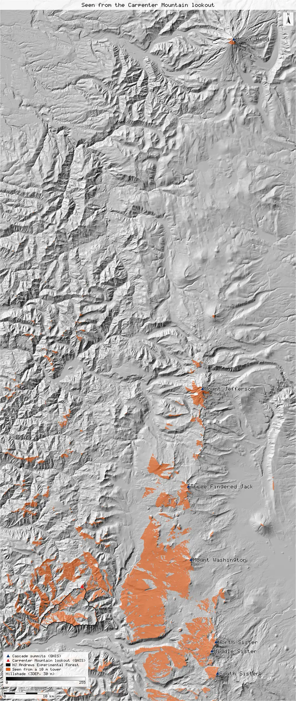
A fire lookout is only as useful as the ground it overlooks. A viewshed from the Carpenter Mountain lookout on a 30 m terrain model, with the earth's curvature, sees all seven Cascade summits it is said to see, Mount Hood 126 km away included, and 37.7% of the HJ Andrews Experimental Forest below it.
- HJ Andrews seen from a 10 m lookout cab37.7%new
- HJ Andrews seen from 2 m above the summit15.8%new
- Named summits in line of sight (of 7)7 summitsnew
[30]
[30]
[38, 41]
Numbers in brackets, like [14], are step numbers in this study's run.json: the NativeGIS call that returned the figure. NativeGIS 0.3.0, recorded 2026-10-31 09:29 UTC.
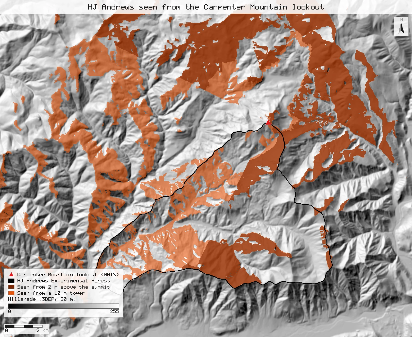
Click or tap a map to open it full screen, then zoom and pan.
What was published
The Carpenter Mountain lookout (1934) stands on a 1,632 m summit at the north edge of the HJ Andrews Experimental Forest. Descriptions of the summit list the Three Sisters, Mount Washington, Three Fingered Jack and Mount Jefferson among the peaks in view, and say Mount Hood can be seen on clear days. These are descriptions, not measurements: no published viewshed gives a number to match, so this study asks whether the terrain allows each sight line, and how much of the forest the lookout overlooks.
Carpenter Mountain (Oregon), Wikipedia · USGS Geographic Names Information System
Published method. None given: the statements are observations from the summit. The encyclopedia article attributes them jointly to two peak registers.
The data and where it came from
All of it is open: downloaded without an account or a form.
| Data | Where | Licence |
|---|---|---|
| USGS 3DEP elevation, exported as two 30 m DEMs (32-bit float GeoTIFF, EPSG:26910) that together cover 66 x 156 km from the Three Sisters to Mount Hood | USGS National Map 3DEP elevation image service (exportImage), no form or account https://elevation.nationalmap.gov/arcgis/rest/services/3DEPElevation/ImageServer | US federal data, public domain |
| Summit points for Carpenter Mountain and the seven Cascade summits (GNIS feature ids 1118625, 1147062, 1146183, 1150082, 1151927, 1151164, 1144246, 1143711), as GeoJSON | The National Map gazetteer (GNIS) map service, Landforms layer query, no form or account https://carto.nationalmap.gov/arcgis/rest/services/geonames/MapServer/5 | US federal data, public domain |
| HJ Andrews Experimental Forest boundary (GI006, boundary83.shp) | HJ Andrews LTER, zip, no form or account https://andrewsforest.oregonstate.edu/sites/default/files/lter/data/studies/spatialdata/gi00601.zip | HJ Andrews data policy (CC BY, acknowledgement requested) |
The input files the run read, pinned by checksum
| File (relative to the data folder) | Bytes | sha256 |
|---|---|---|
samples/dem3dep/cascades_south_26910_30m.tif | 23,485,676 | 92fc3abb531ce243… |
samples/dem3dep/cascades_north_26910_30m.tif | 23,687,869 | c879bd52306dff1b… |
samples/gnis/r20_summits.geojson | 1,609 | b1f917faad779c17… |
samples/hja-open/gi00601/x/boundary83.shp | 10,540 | 0774de0a9ebd9693… |
Full checksums are in run.json. Replay refuses an input whose checksum differs.
Method
- Open the two 3DEP exports and join them into one 30 m DEM: the southern one widened to the full extent (gis_process resample, nearest), the northern one filling the rest (gis_process calc nodata_to). The two exports share one grid, so the join copies cells and does not resample them. The image service refuses a single 30 m export of this size.
- Open the GNIS summit points, split Mount Hood's two points into separate features (explode) and reproject everything to NAD83 / UTM zone 10N. The observer is GNIS's Carpenter Mountain point.
- Check the observer's position: the DEM at the GNIS point, and the highest cell within 60 m of it (buffer, zonal max).
- Viewshed from the lookout (gis_process viewshed): R2 ray sweep over the whole DEM; eye 10 m above the ground (a lookout cab on a tower; the main case); target height 0, so a cell counts as seen when its ground surface is in view; earth curvature less refraction (k = 0.13) lowers distant ground by 0.87 d² / 2R. Two more runs: the eye 2 m above the ground, and the 10 m eye on a flat earth.
- Read the three viewsheds at each GNIS summit point (gis_process sample, nearest cell), and the share of cells within 100 m of each point that the 10 m viewshed sees (buffer, zonal mean).
- Share of the HJ Andrews Experimental Forest in view: the mean of the 0/1 viewshed over the forest's cells (zonal mean over the GI006 boundary), for each of the three viewsheds.
- Render the maps: the region from the Three Sisters to Mount Hood with the summits labelled, and the forest close up with the 10 m and 2 m viewsheds, over a hillshade of the same DEM.
The run made 41 NativeGIS calls: gis_open × 4, gis_process × 24, gis_info × 1, gis_query × 8, gis_render × 4.
The numbers
The summits it is said to see
| Summit (GNIS id) | Distance (km) | Direction | DEM at the point (m) | Curvature less refraction (m) | 10 m eye | 2 m eye | 10 m, flat earth | Cells within 100 m seen (10 m eye) |
|---|---|---|---|---|---|---|---|---|
| North Sister 1147062 | 32.3 | ESE | 3,043 | 71 | seen | seen | seen | 63% of 35 |
| Middle Sister 1146183 | 32.3 | ESE | 3,053 | 71 | seen | seen | seen | 63% of 35 |
| South Sister 1150082 | 35.8 | ESE | 3,152 | 88 | seen | seen | seen | 23% of 35 |
| Mount Washington 1151927 | 25.0 | ENE | 2,339 | 43 | seen | seen | seen | 74% of 34 |
| Three Fingered Jack 1151164 | 32.5 | NE | 2,360 | 72 | seen | seen | seen | 67% of 36 |
| Mount Jefferson 1144246 | 51.5 | NNE | 3,181 | 181 | seen | seen | seen | 57% of 35 |
| Mount Hood ("on clear days") 1143711 | 126.4 | NNE | 3,420 | 1,091 | seen | seen | seen | 43% of 37 |
| Mount Hood, GNIS's second point 1143711 | 126.9 | NNE | 2,999 | 1,099 | hidden | hidden | hidden | 0% of 35 |
Visibility at the cell nearest each GNIS point [30]; cells within 100 m [34]; viewsheds [16, 18, 20]. Distances and directions are from GNIS's Carpenter Mountain point (DEM 1,604 m; highest cell within 60 m 1,610 m [15]). The curvature column is 0.87 d² / 2R, the amount the viewshed lowers the ground at that distance. Units: metres and kilometres in NAD83 / UTM zone 10N; 30 m cells.
How much of HJ Andrews the lookout overlooks
| Viewshed | Share of the forest seen | Area seen across the whole DEM (km²) |
|---|---|---|
| Eye 10 m above the summit (lookout cab), curvature on | 37.7% [38] | 552 [16] |
| Eye 2 m above the summit, curvature on | 15.8% [41] | 483 [18] |
| Eye 10 m, flat earth | 37.8% [44] | 594 [20] |
Method: the mean of the 0/1 viewshed over the cells whose centre is inside the GI006 forest boundary; n = 70,773 cells of 900 m². No published figure exists for this share.
What the numbers say, and what they do not
- All seven summits are in line of sight. The cell at each GNIS summit point is seen from the 10 m eye, from the 2 m eye, and with or without curvature. That is consistent with the descriptions, which is all a viewshed can show: it says the terrain does not block the line, not that the peak is visible through haze or cloud.
- Mount Hood. It is the far one: 126.4 km north-north-east, where curvature less refraction lowers the ground by about 1,091 m. The summit still clears every ridge in between, and 43% of the cells within 100 m of it are in view. That fits the "clear days" wording: distance and haze, not terrain, decide whether it shows. GNIS also lists a second point for Mount Hood, 560 m to the north-north-west and 2,999 m high on the DEM; that point is hidden behind the summit, so it is shown in the table but not counted.
- The forest below. From a 10 m cab the lookout overlooks 37.7% of HJ Andrews; from 2 m above the summit, 15.8%. Most of the forest lies in valleys that fall away from the lookout to the south-west, so the cab's height matters more than curvature here (37.8% on a flat earth).
- The summit position. The coordinates quoted in the encyclopedia article (44.30167 N, 122.13750 W, from a peak register) fall about 2 km north of GNIS's point, on a slope far below the summit on the DEM (checked before the run, not recorded). We used GNIS, where the DEM reaches 1,604 m at the point and 1,610 m within 60 m of it; a 30 m cell averages the summit rock, so both are below the published 1,632 m.
Replay it yourself
The run file records every call, its arguments, the checksums of the files it read and the numbers it returned. Replaying it repeats every call in a fresh NativeGIS session and checks that each answer comes out the same.
- Make an empty data folder and fetch the inputs into it exactly as below (bash; the folder layout is the one the run file expects):
cd /path/to/an/empty/folder
mkdir -p samples/dem3dep && curl -fL -o samples/dem3dep/cascades_south_26910_30m.tif 'https://elevation.nationalmap.gov/arcgis/rest/services/3DEPElevation/ImageServer/exportImage?bbox=550000,4878000,616000,4956000&bboxSR=26910&imageSR=26910&size=2200,2600&format=tiff&pixelType=F32&noData=-9999&interpolation=RSP_BilinearInterpolation&compression=LZ77&f=image'
mkdir -p samples/dem3dep && curl -fL -o samples/dem3dep/cascades_north_26910_30m.tif 'https://elevation.nationalmap.gov/arcgis/rest/services/3DEPElevation/ImageServer/exportImage?bbox=550000,4956000,616000,5034000&bboxSR=26910&imageSR=26910&size=2200,2600&format=tiff&pixelType=F32&noData=-9999&interpolation=RSP_BilinearInterpolation&compression=LZ77&f=image'
mkdir -p samples/gnis && curl -fL -o samples/gnis/r20_summits.geojson 'https://carto.nationalmap.gov/arcgis/rest/services/geonames/MapServer/5/query?where=state_alpha%3D%27OR%27+AND+gaz_featureclass%3D%27Summit%27+AND+county_name+IN+%28%27Linn%27%2C%27Lane%27%2C%27Clackamas%27%29+AND+gaz_name+IN+%28%27Carpenter+Mountain%27%2C%27North+Sister%27%2C%27Middle+Sister%27%2C%27South+Sister%27%2C%27Mount+Washington%27%2C%27Three+Fingered+Jack%27%2C%27Mount+Jefferson%27%2C%27Mount+Hood%27%29&outFields=gaz_id%2Cgaz_name%2Ccounty_name&orderByFields=gaz_id&f=geojson'
mkdir -p samples/hja-open/gi00601 && curl -fL -o samples/hja-open/gi00601/gi00601.zip https://andrewsforest.oregonstate.edu/sites/default/files/lter/data/studies/spatialdata/gi00601.zip && unzip -o samples/hja-open/gi00601/gi00601.zip -d samples/hja-open/gi00601/x
- Download run.json (84,901 bytes, sha256
7c0b5469fd801a957b7b754e2d6c77bffaa7109d43b884a3fbcec88346d60741). - Ask your assistant to replay it with NativeGIS, or call the tool directly:
gis_replay {"action": "replay",
            "file": "<absolute path to the run.json you downloaded>",
            "inputRoot": "<your data folder>",
            "outputRoot": "<a new, empty folder>"}
Paths in the run file are relative to the data folder (inputRoot), and outputs go under outputRoot, so nothing depends on where the original run lived.
Files
- run.json: the recorded run: every call, its arguments and the numbers it returned
Limits
- Bare-earth terrain: the DEM has no trees. Forest near the lookout would hide some of the near ground from a 2 m eye, and the 10 m cab is our assumption for a tower lookout, not a surveyed height.
- A 30 m DEM averages each summit and ridge over 900 m². A sight line that clears a ridge by a few metres here might not clear it on the ground; none of the seven summit lines was tested against a finer DEM.
- With the eye 2 m above a 30 m cell, the few cells next to the summit decide whole sectors of the view; the straight edges that radiate from the lookout on the close-up map come from that, not from the terrain far away.
- Refraction varies with the weather; k = 0.13 is the usual standard value. The R2 sweep marks a cell seen when any ray through it sees it (Franklin and Ray 1994).
- The view statements come from an encyclopedia article citing two peak registers, not from a measured study; HJ Andrews' own pages on the lookout are no longer online.