How much of the Andrews is old growth? Checking the 40% against two open maps
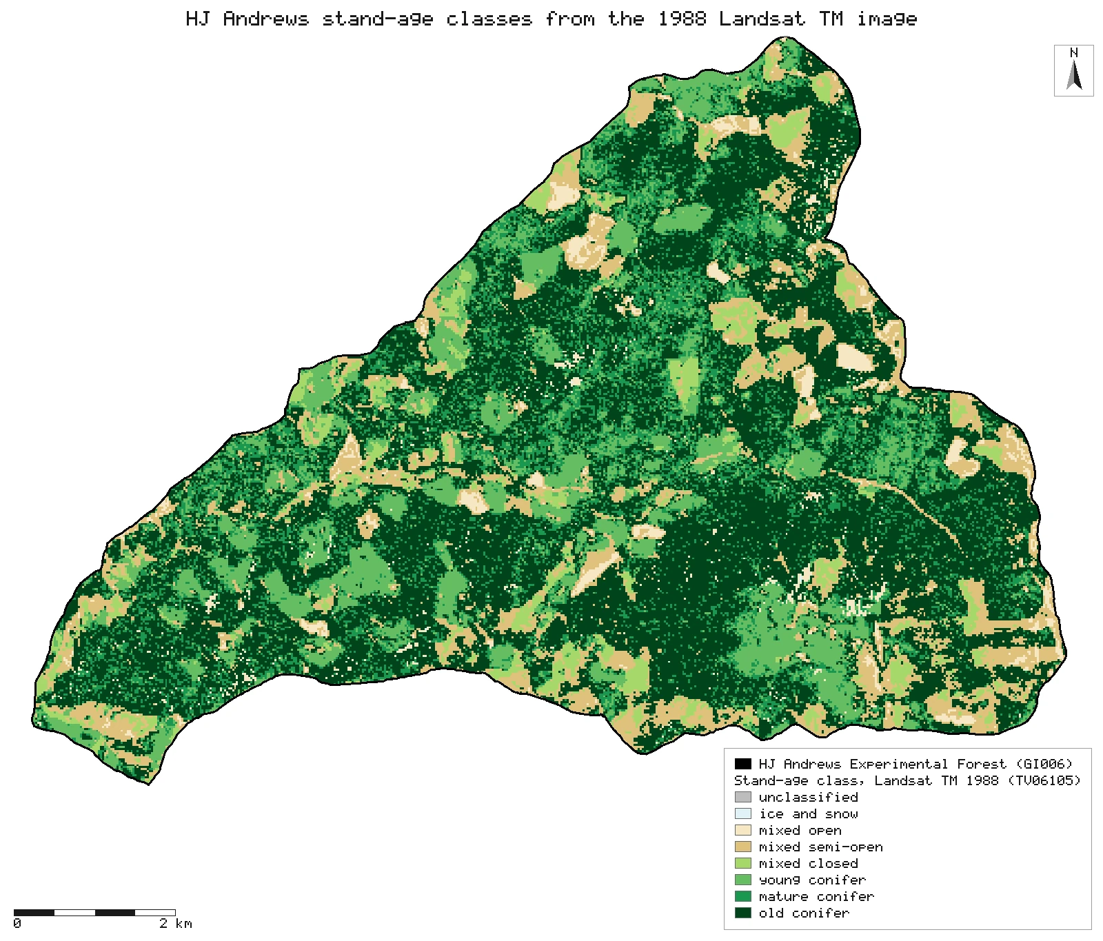
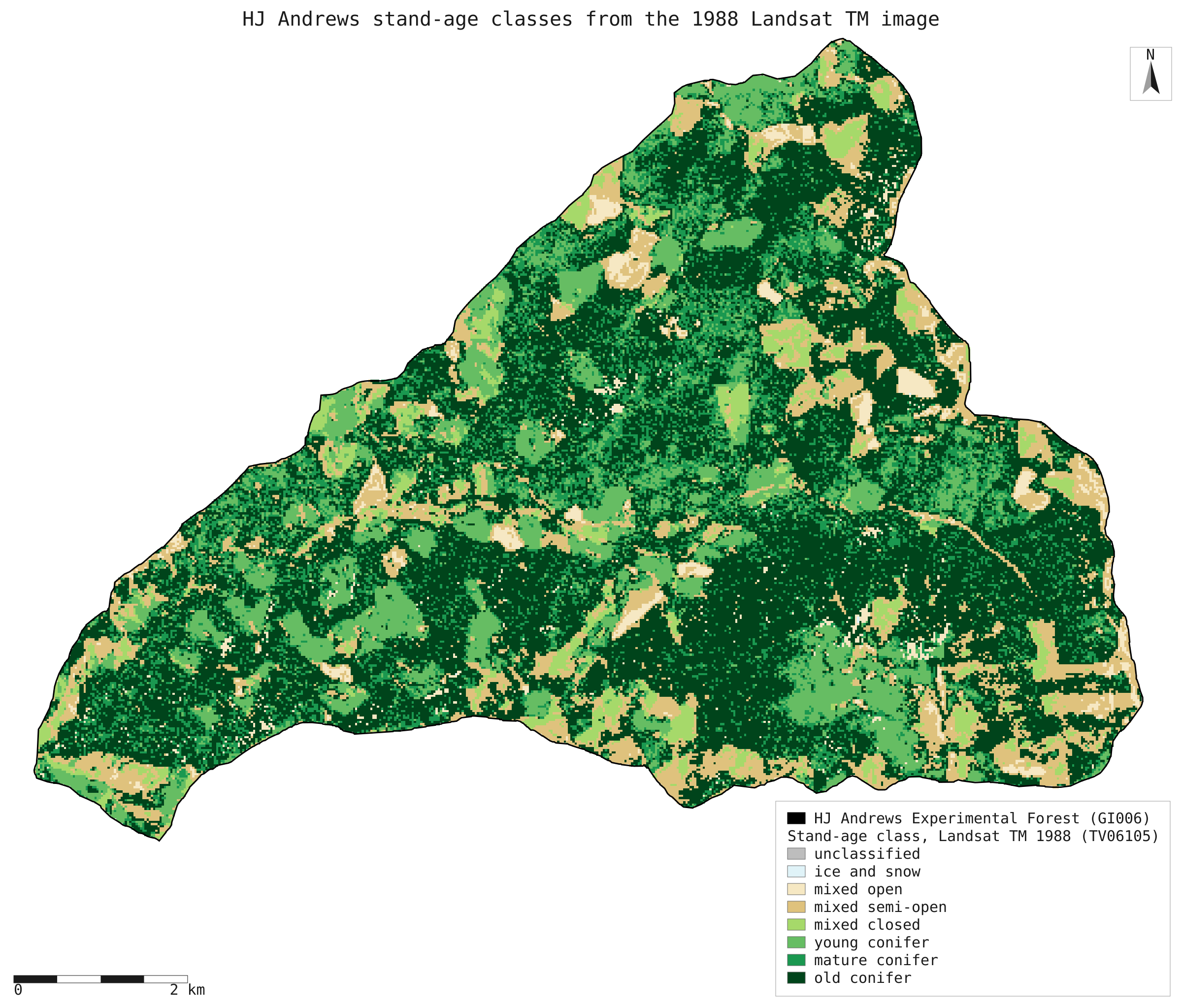
HJ Andrews says about 40% of the forest was old growth before the 2020 fires. Neither open map gives 40% inside the forest boundary: the 1988 Landsat stand-age map puts 46.1% in its old-conifer class, close to the 45% a 1984 introduction gave for trees over 400 years, while the Forest Service stand-origin map puts 30.0% in stands that began before 1600 and 59.3% in stands that began before 1800. Counted as 400 years or more by 2023 instead of by 2000, the same map gives 49.6%, so 40% falls between the two reference years.
- Old conifer class, 1988 Landsat TM map (by cell centre)40.0% → 46.1% +6.1 ptsexplained why
- Stands that began before 1600, Forest Service stand-origin map (area-weighted)40.0% → 30.0% −10.0 ptsexplained why
- Stands 400 years or more by 2023 (origin 1623 or earlier), context only: the page does not say which year it counts from40.0% → 49.6% +9.6 ptsexplained why
- Stands that began before 1600 (the same definition: 400 years or more by 2000)45.0% → 30.0% −15.0 ptsexplained why
- Old conifer class, 1988 Landsat TM map (a spectral class with no age threshold)45.0% → 46.1% +1.1 ptswithin tolerance
[5]
[28]
[31]
Numbers in brackets, like [14], are step numbers in this study's run.json: the NativeGIS call that returned the figure. NativeGIS 0.3.0, recorded 2026-10-31 15:57 UTC.
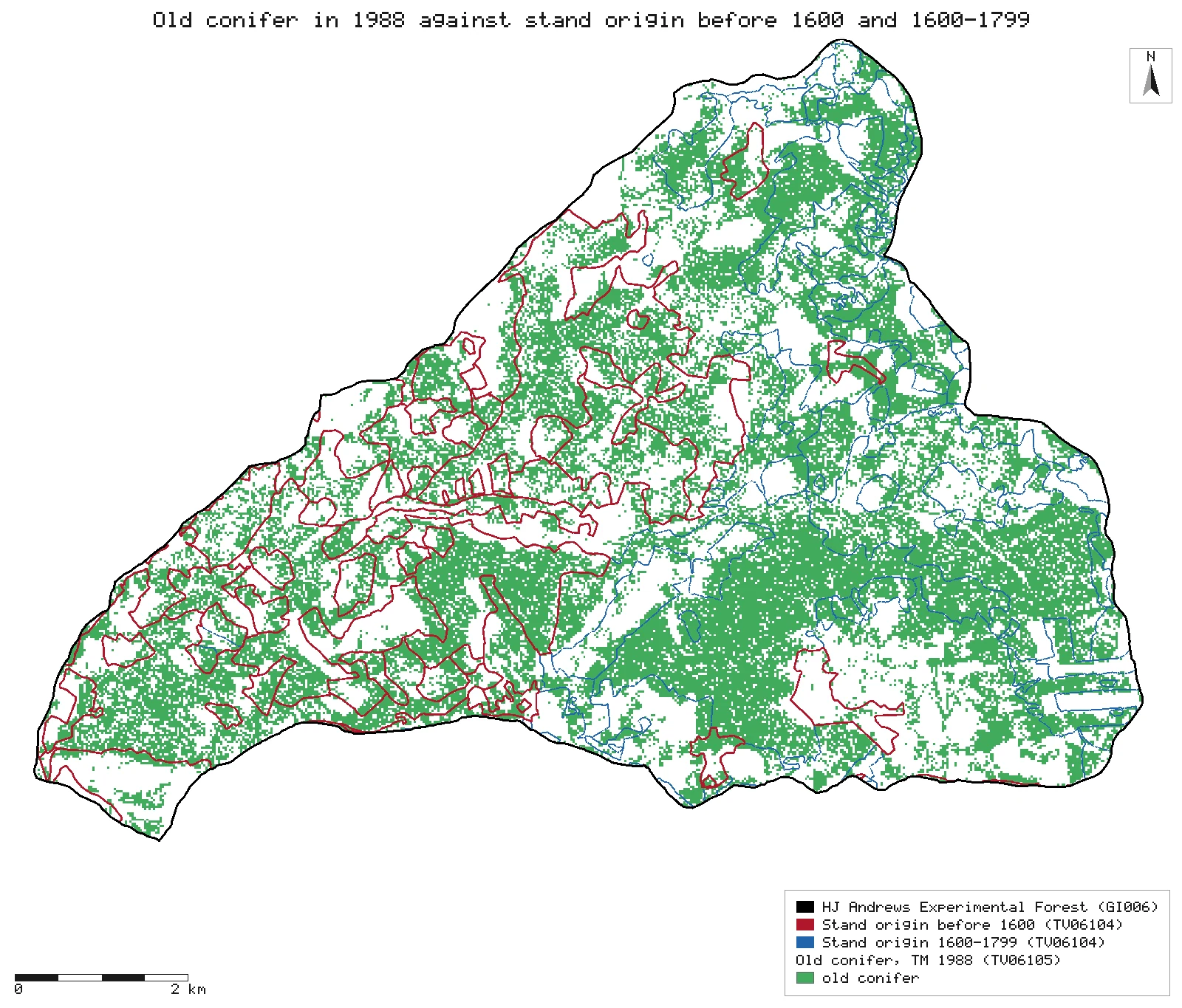
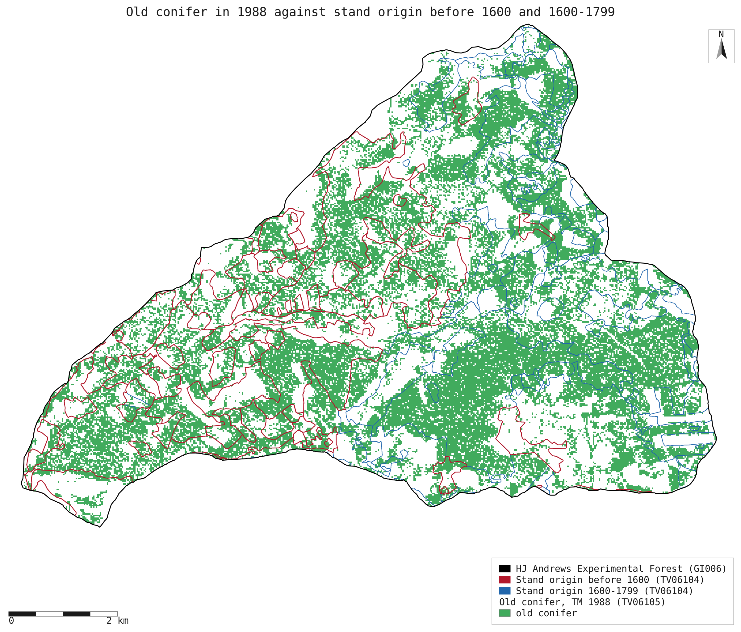
Old conifer in 1988 against stand origin
The 1988 old-conifer class (green) under the TV06104 stands that began before 1600 (red) and in 1600–1799 (blue), both as published. The polygons sit about 175 m east of the grid: about 94 m of that is TV06104's own offset and about 80 m the grid's; see Why any numbers differ.
Click or tap a map to open it full screen, then zoom and pan.
What was published
HJ Andrews' Fast Facts page says that before the fires since 2020 "we estimated that 40%" of the Experimental Forest was covered in old growth. Its "Old-growth trees area" page describes old growth by 400- to 500-year-old emergent Douglas-fir and a complex vertical structure. Neither page names the map or the year behind the 40%. A 1984 introduction to the forest gives a different figure: stands whose dominant trees are over 400 years old cover about 45 percent.
Fast Facts (HJ Andrews) · Old-growth trees area (HJ Andrews) · 1984 introduction (scanned PDF)
Published method. Not given. The question here is which open map gives the figure, and under which definition of old growth.
The data and where it came from
All of it is open: downloaded without an account or a form.
| Data | Where | Licence |
|---|---|---|
| Stand-age classification of a 1988 Landsat TM image (TV06105; Cohen & Fiorella, 1994): grid tmveg88, 25 m cells, ArcInfo E00 export, NAD83 / UTM zone 10N. Classes from tv06105_fgdc.xml: 1 ice snow, 2 water, 7 mixed open, 8 mixed semi-open, 9 mixed closed, 10 young conifer, 11 mature conifer, 12 old conifer | HJ Andrews LTER, 524 kB zip, no form or account https://andrewsforest.oregonstate.edu/sites/default/files/lter/data/studies/spatialdata/tv06105.zip | HJ Andrews data policy (CC BY, acknowledgement requested) |
| Willamette National Forest vegetation polygons clipped to the Andrews (TV06104, hjaveg8.shp; compiled July 2000, published as the 2002 classification), with YR_ORIGIN, the year of origin of natural and managed stands | HJ Andrews LTER, 1.9 MB zip, no form or account https://andrewsforest.oregonstate.edu/sites/default/files/lter/data/studies/spatialdata/tv06104.zip | HJ Andrews data policy (CC BY, acknowledgement requested) |
| The 2008 version of the same stand polygons (TV06101, hja_veg2008.shp), used only to check where TV06104 sits: its managed stands carry real origin years, its natural stands the placeholder 1111 | HJ Andrews LTER, zip, no form or account https://andrewsforest.oregonstate.edu/sites/default/files/lter/data/studies/spatialdata/tv06101.zip | HJ Andrews data policy (CC BY, acknowledgement requested) |
| HJ Andrews Experimental Forest boundary (GI006, boundary83.shp) | HJ Andrews LTER, zip, no form or account https://andrewsforest.oregonstate.edu/sites/default/files/lter/data/studies/spatialdata/gi00601.zip | HJ Andrews data policy (CC BY, acknowledgement requested) |
| Gauged watershed boundaries from a 10 m DEM (HF014-04, wsheddem.shp), used only to check how the two maps line up | HJ Andrews LTER, zip, no form or account https://andrewsforest.oregonstate.edu/sites/default/files/lter/data/studies/spatialdata/hf01404.zip | HJ Andrews data policy (CC BY, acknowledgement requested) |
The input files the run read, pinned by checksum
| File (relative to the data folder) | Bytes | sha256 |
|---|---|---|
samples/hja-open/tv06105/x/tv06105.e00 | 3,879,137 | 93b1638e9dbb7c97… |
samples/hja-open/gi00601/x/boundary83.shp | 10,540 | 0774de0a9ebd9693… |
samples/hja-open/tv06104/x/hjaveg8.shp | 2,754,280 | 153dac389d063426… |
samples/hja-open/tv06101/x/hja_veg2008.shp | 3,098,488 | ef83a267c95a7d1f… |
samples/hja-open/hf01404/x/wsheddem.shp | 149,876 | 6cbafbe316d2fa08… |
Full checksums are in run.json. Replay refuses an input whose checksum differs.
Method
- Open the 1988 stand-age grid straight from its E00 export (gis_open; the CRS, EPSG:26910, comes from the file's PRJ section), and the forest boundary.
- Count each class inside the boundary by cell centre with one zonal class tally over the boundary (gis_process zonal classes:true): cells, and the share of each class.
- Cross-check by area: polygonize the grid into regions of one class, clip the regions to the boundary, measure them and summarize the area by class (polygonize, clip, measure, summarize).
- Stand origin: clip the TV06104 polygons to the boundary (area-weighted), bin YR_ORIGIN with a field calculation (before 1600, 1600–1799, 1800–1899, 1900–1949, 1950 or later, and no year), add each piece's area and summarize area by bin, and by single origin year for the shares at other cutoffs (clip, fieldCalc, summarize).
- Cross the two maps: count old-conifer cells and open-to-young cells (classes 7–10) in each origin bin (zonal over the binned polygons, then summarize by bin). Repeat with the polygons moved 100, 175 and 250 m west and 25 m south (translate) to find the shift that lines the two maps up.
- Which map is off: (1) the centroids of TV06104's stands over 2 ha against the same stands in TV06101, the 2008 version of the map (centroid, listed with stand number and area; the page pairs stands present once in each with areas within 5% and takes the median offset); (2) the share of three watersheds clearcut whole between 1962 and 1975 (WS1, WS6, WS10, HJ Andrews' DEM boundaries) in stands of 1950 or later, for each stand map where published and moved 94 and 175 m west; (3) the 1988 grid's open-to-young share in TV06101's stands of 1950 or later, with the stands moved 0 to 120 m west.
- Render the 1988 classes inside the boundary, and the old-conifer class against the stands of origin before 1600 and 1600–1799.
The run made 170 NativeGIS calls: gis_open × 5, gis_query × 34, gis_process × 73, gis_close × 54, gis_render × 4.
Published numbers next to ours
The 1988 stand-age classes inside the forest
| 1988 TM class (TV06105) | Cells (25 m) | Hectares | Share by cell centre | Share by clipped area |
|---|---|---|---|---|
| 12 old conifer | 46,986 | 2,937 | 46.1% | 46.1% |
| 11 mature conifer | 17,025 | 1,064 | 16.7% | 16.7% |
| 10 young conifer | 15,870 | 992 | 15.6% | 15.6% |
| 9 mixed closed | 5,104 | 319 | 5.0% | 5.0% |
| 8 mixed semi-open | 13,877 | 867 | 13.6% | 13.6% |
| 7 mixed open | 3,040 | 190 | 3.0% | 3.0% |
| 0, 1, 2 unclassified, ice and snow, water | 8 | 0.5 | 0.01% | 0.01% |
| Inside the boundary | 101,910 | 6,369 | 100% | 6,369 ha |
Cell counts from one zonal class tally over the boundary [4, 5] (a cell counts when its centre is inside); clipped areas [14]. Published: Fast Facts 40% old growth before the 2020 fires; 1984 introduction about 45% in stands with dominant trees over 400 years. Units: 25 m cells (0.0625 ha) and hectares in NAD83 / UTM zone 10N.
Stand origin, and how much of it was old conifer in 1988
| Stand origin (TV06104 YR_ORIGIN) | Polygon pieces | Hectares | Share of the forest | Old conifer in 1988, as published | Old conifer in 1988, polygons moved 175 m W |
|---|---|---|---|---|---|
| before 1600 | 25 | 1,913 | 30.0% | 48.0% | 58.4% |
| 1600–1799 | 38 | 1,867 | 29.3% | 59.9% | 69.5% |
| 1800–1899 | 51 | 707 | 11.1% | 40.1% | 35.8% |
| 1900–1949 | 7 | 71 | 1.1% | 33.3% | 29.6% |
| 1950 or later | 158 | 1,522 | 23.9% | 31.8% | 11.1% |
| no year (rock, meadow, water, buildings) | 85 | 289 | 4.5% | 38.2% | 22.5% |
Areas [28] (polygons clipped to the boundary, area-weighted); old-conifer share of each bin's 25 m cells [39, 64]. Open-to-young share of the 1950-or-later stands with the polygons moved 0, 100, 175 and 250 m west of the grid: 57.1%, 71.6%, 82.2%, 74.4% [39, 51, 64, 77]. The 175 m is the two maps' offsets added together; see below.
Shares by origin cutoff
| Stands of TV06104 that began… | Over 400 years old in | Share of the forest |
|---|---|---|
| before 1600 | 2000 | 30.0% |
| before 1620 | 2020 | 32.9% |
| in 1623 or earlier | 2023 (400 years or more) | 49.6% |
| before 1700 | – | 51.6% |
| before 1800 | – | 59.3% |
Area by origin year inside the boundary [29, 31], as a share of the clipped total. Origin years recorded from 1600 to 1623: 1610, 1620, 1623; the 1623 cohort alone is 16.7% of the forest. Context, not a match: Fast Facts does not say which map, year or threshold its 40% used.
How the maps line up
| Registration test | Where published | Moved 94 m W, 18 m S | Moved 175 m W, 25 m S |
|---|---|---|---|
| TV06101 (2008): share of WS1, WS6, WS10 in stands of 1950 or later | 94.6% | 91.1% | 85.9% |
| TV06104 (2000): the same | 89.0% | 94.8% | 93.5% |
| 1988 grid: open-to-young cells (classes 7–10) in… | Where published | Moved 40 m W | Moved 80 m W | Moved 120 m W | Moved 80 m W, 20 m S |
|---|---|---|---|---|---|
| TV06101's stands of 1950 or later | 70.5% | 77.2% | 83.4% | 82.6% | 83.4% |
| WS1, WS6, WS10 | 74.1% | – | 75.2% | – | – |
Stand centroids of TV06104 and TV06101 over 2 ha [88, 89, 90, 98, 99, 100]: 459 stands present once in each with areas within 5%; TV06104 minus TV06101, median 93.8 m east and 17.9 m north. Watershed shares [143, 153, 164, 113, 123, 134]; grid shares [172, 176, 181, 186, 191, 195, 198]. Watershed boundaries from HJ Andrews' 10 m DEM (HF014-04).
Why any numbers differ
- No open map gives 40% inside the forest boundary. The 1988 old-conifer class covers 46.1% of the forest (46,986 of 101,910 cells), and the stands of TV06104 that began before 1600 cover 30.0%. Counting by area instead of by cell centre changes the 1988 figure by less than 0.1 point. The Fast Facts page names no source, so 40% may come from another map, another boundary or another definition.
- The 1984 figure matches the 1988 map's class, not its definition. 46.1% old conifer in 1988 is close to the 1984 introduction's "about 45 percent". But the TM classes carry no age threshold in their metadata, and the 1984 figure is for dominant trees over 400 years; the map that does record age, TV06104, puts only 30.0% in stands that began before 1600, which is 400 years or more by 2000. Stands that began before 1800 cover 59.3%.
- Where 40% could fall: the year "over 400 years" is counted from. In TV06104, stands that began before 1600, over 400 years old by 2000, cover 30.0% of the forest; before 1620 (by 2020) 32.9%; in 1623 or earlier (400 years or more by 2023) 49.6%; before 1700 51.6%. The step from 32.9% to 49.6% is almost all one cohort: stands with origin year 1623 cover 16.7% of the forest. Fast Facts' 40% falls between the two reference years, so an estimate made with a 400-year threshold could land on either side depending on the year and on whether the 1623 cohort counts. This is context, not a match: the page names no map, year or threshold.
- Old conifer is not the same land as old stand origin. As published, 48.0% of the cells in the before-1600 stands are old conifer in 1988, and 31.8% of the cells in stands that began in 1950 or later are too, although almost all of that land was cut and replanted between 1950 and 1988.
- The two maps sit about 175 m apart, and both are off. Moving the TV06104 polygons 175 m west and 25 m south raises the old-conifer share of the before-1600 stands to 58.4% and lowers that of the 1950-or-later stands to 11.1%; their open-to-young share rises from 57.1% to 82.2%. Of the shifts tried (100, 175 and 250 m west), 175 m fits best. An earlier version of this page put all 175 m on TV06104. Matching 459 stands that appear in both TV06104 and the 2008 version of the same map (TV06101), TV06104 sits a median 93.8 m east and 17.9 m north. Its metadata records a 2009 projection from NAD27 to NAD83 with no datum transformation listed, which displaces features by the NAD27 to NAD83 shift, of this size and direction here. Against the three watersheds clearcut whole, TV06101 fits where published (94.6% of their area in stands of 1950 or later, against 91.1% and 85.9% moved 94 and 175 m west), and TV06104 fits best moved 94 m west and 18 m south (94.8%, against 89.0% where published and 93.5% moved 175 m). The rest is the 1988 grid's: TV06101's stands of 1950 or later are 70.5% open to young in the grid where published, 77.2% moved 40 m west, 83.4% moved 80 m west and 82.6% moved 120 m west, so the grid sits about 80 m west. In the watersheds the grid's share barely moves (74.1% where published, 75.2% moved 80 m west), because each watershed is large against the offset. The 175 m is the two offsets added: about 94 m east in TV06104 and about 80 m west in the grid. Neither offset changes the area shares above; both change any cell-by-cell comparison.
Replay it yourself
The run file records every call, its arguments, the checksums of the files it read and the numbers it returned. Replaying it repeats every call in a fresh NativeGIS session and checks that each answer comes out the same.
- Make an empty data folder and fetch the inputs into it exactly as below (bash; the folder layout is the one the run file expects):
cd /path/to/an/empty/folder
mkdir -p samples/hja-open/tv06105 && curl -fL -o samples/hja-open/tv06105/tv06105.zip https://andrewsforest.oregonstate.edu/sites/default/files/lter/data/studies/spatialdata/tv06105.zip && unzip -o samples/hja-open/tv06105/tv06105.zip -d samples/hja-open/tv06105/x
mkdir -p samples/hja-open/tv06104 && curl -fL -o samples/hja-open/tv06104/tv06104.zip https://andrewsforest.oregonstate.edu/sites/default/files/lter/data/studies/spatialdata/tv06104.zip && unzip -o samples/hja-open/tv06104/tv06104.zip -d samples/hja-open/tv06104/x
mkdir -p samples/hja-open/tv06101 && curl -fL -o samples/hja-open/tv06101/tv06101.zip https://andrewsforest.oregonstate.edu/sites/default/files/lter/data/studies/spatialdata/tv06101.zip && unzip -o samples/hja-open/tv06101/tv06101.zip -d samples/hja-open/tv06101/x
mkdir -p samples/hja-open/gi00601 && curl -fL -o samples/hja-open/gi00601/gi00601.zip https://andrewsforest.oregonstate.edu/sites/default/files/lter/data/studies/spatialdata/gi00601.zip && unzip -o samples/hja-open/gi00601/gi00601.zip -d samples/hja-open/gi00601/x
mkdir -p samples/hja-open/hf01404 && curl -fL -o samples/hja-open/hf01404/hf01404.zip https://andrewsforest.oregonstate.edu/sites/default/files/lter/data/studies/spatialdata/hf01404.zip && unzip -o samples/hja-open/hf01404/hf01404.zip -d samples/hja-open/hf01404/x
- Download run.json (637,823 bytes, sha256
462c3ae4bbb105954bb60c6efcedf2a2485df0096a6d30f6e6a832dc62b10be7). - Ask your assistant to replay it with NativeGIS, or call the tool directly:
gis_replay {"action": "replay",
            "file": "<absolute path to the run.json you downloaded>",
            "inputRoot": "<your data folder>",
            "outputRoot": "<a new, empty folder>"}
Paths in the run file are relative to the data folder (inputRoot), and outputs go under outputRoot, so nothing depends on where the original run lived.
Files
- run.json: the recorded run: every call, its arguments and the numbers it returned
- tm88_stand_age_classes.svg: the full-detail map of the 1988 classes
- old_conifer_vs_origin.svg: the full-detail map of old conifer against stand origin
Limits
- The 1988 classification was made by Cohen and Fiorella; its metadata lists the class names but not the stand ages or canopy rules behind them, so "old conifer" is a spectral class, not a measured age.
- TV06104 was compiled from Forest Service district records in 2000. Its YR_ORIGIN for an old natural stand is an estimate from the stand's oldest cohort, and 4.5% of the forest (rock, meadow, water and buildings) has no year.
- Both figures are for the forest before the 2020 fires and before any later change. Neither map is the source of HJ Andrews' 40%, which the page does not name.
- The 1984 introduction is a scanned copy with no author given; its figure is quoted as it appears there.
- The offsets are measured, not corrected: every share above uses the maps as published. The grid's offset comes from the best of the shifts tried (0, 40, 80 and 120 m west), so it is good to about 20 m; TV06104's comes from 459 matched stands.
- TV06101 is used only for registration. Its natural stands carry the placeholder origin year 1111, so it cannot give an old-growth share.