Holiday Farm Fire 2020, and 70% of the Andrews Forest burned since 2020
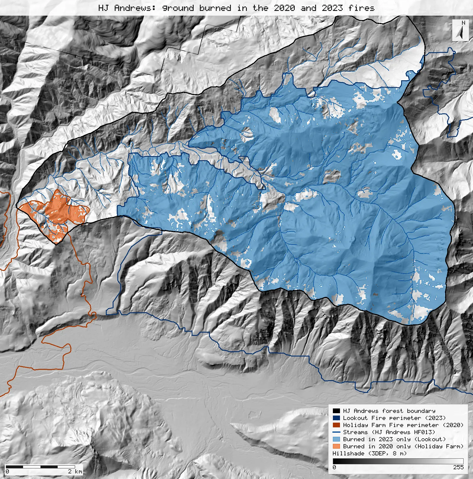
The MTBS acreage table for the 2020 Holiday Farm Fire comes back from the published rasters with the same total, three of six classes to the acre, high severity 1 acre off and two classes 3 acres apart. HJ Andrews says fires since 2020 burned about 70% of the forest. That matches the area the two fires covered: 69.7% to 70.5% of the forest, by MTBS, BAER and NIFC footprints alike. The ground that actually burned is less, 58%. The two fires do not overlap inside the forest.
- Total burned area174,390 ac → 174,390 ac 0match
- Unburned to low15,965 ac → 15,968 ac +3 ac (+0.017%)within tolerance
- Low46,878 ac → 46,875 ac −3 ac (−0.006%)within tolerance
- Moderate51,287 ac → 51,287 ac 0match
- High57,988 ac → 57,987 ac −1 ac (−0.001%)within tolerance
- Inside the 2020 or 2023 NIFC final incident perimeter70% → 70.5% +0.5 ptswithin tolerance
- Inside either BAER soil burn severity map70% → 70.2% +0.2 ptsmatch
- Inside the 2020 or 2023 MTBS perimeter70% → 69.7% −0.3 ptsmatch
- Contrast: actually burned (MTBS low to high severity)70% → 58.4% −11.6 ptswording why
[6, 8]
[28, 74, 81, 66]
[52]
[24, 29]
Numbers in brackets, like [14], are step numbers in this study's run.json: the NativeGIS call that returned the figure. NativeGIS 0.3.0, recorded 2026-10-31 15:24 UTC.
Click or tap a map to open it full screen, then zoom and pan.
What was published
Two claims. First, the "Acreage of Burn Severity" table on the MTBS map of the 2020 Holiday Farm Fire, with the thresholds that make its classes (perimeter attributes IncGreen_T, Low_T, Mod_T, High_T). Second, HJ Andrews' statement that fires since 2020 burned "ca. 70%" of the forest. The statement does not say how "burned" was measured, so the area the two fires covered is measured with three footprints (the NIFC final incident perimeters, the BAER soil burn severity maps and the MTBS perimeters), and, as a contrast, the share that actually burned (MTBS low, moderate or high severity in either fire).
MTBS program · HJ Andrews copy of the Holiday Farm Fire map (PDF) · HJ Andrews facts: old-growth trees area
Published method. MTBS does not publish how the acreage table is tallied. As in the Lookout Fire reproduction (R1), it is read as a count of 30 m cells of the published class raster inside the published perimeter. HJ Andrews gives no method, boundary, date or source for its 70%.
The data and where it came from
All of it is open: downloaded without an account or a form.
| Data | Where | Licence |
|---|---|---|
| MTBS fire bundle for OR4417212223120200908 (Holiday Farm): dNBR, dNBR6 and RdNBR GeoTIFFs (30 m, USA Contiguous Albers), the burn perimeter and mask shapefiles, metadata and the map PDF | Re-hosted by the HJ Andrews LTER, 44.1 MB zip, no form or account https://andrewsforest.oregonstate.edu/sites/default/files/lter/fsdbdata/gis/HFF_or4417212223120200908.zip | US federal data, public domain |
| MTBS fire bundle for OR4422212214620230806 (Lookout Fire 2023): perimeter and dNBR6 severity classes | Re-hosted by the HJ Andrews LTER, 8.3 MB zip, no form or account https://andrewsforest.oregonstate.edu/sites/default/files/lter/fsdbdata/gis/LF_or4422212214620230806.zip | US federal data, public domain |
| NIFC WFIGS interagency fire perimeters for the Holiday Farm Fire (incident 2020-ORWIF-200430) and the Lookout Fire (2023-ORWIF-230327): each incident's final perimeter, GeoJSON in EPSG:5070 from the feature service | National Interagency Fire Center, WFIGS Interagency Perimeters feature service (query, f=geojson), 0.4 and 0.3 MB, no form or account https://services3.arcgis.com/T4QMspbfLg3qTGWY/arcgis/rest/services/WFIGS_Interagency_Perimeters/FeatureServer/0 | US federal data, public domain |
| BAER soil burn severity, final maps of both fires (items HolidayFarm_SBS_final and lookout_or4422212214620230806_sbs; classes 1 to 4, 15 = not mapped), 20 m cells, NAD83 UTM zone 10N | USFS Enterprise Data Warehouse BAER soil burn severity image service, each exported on the item's own 20 m grid and extent with no no-data value, uncompressed GeoTIFF, 3.5 and 2.6 MB, no form or account https://imagery.geoplatform.gov/iipp/rest/services/Fire_Aviation/USFS_EDW_BAER_SoilBurnSeverityClassification/ImageServer | US federal data, public domain |
| HJ Andrews Experimental Forest boundary (GI006, boundary83.shp), NAD83 UTM zone 10N | HJ Andrews LTER, 175 kB zip, no form or account https://andrewsforest.oregonstate.edu/sites/default/files/lter/data/studies/spatialdata/gi00601.zip | HJ Andrews data policy (CC BY, acknowledgement requested) |
| USGS 3DEP elevation, exported twice as a DEM (32-bit float GeoTIFF, EPSG:5070): 8 m cells for the forest's window and 25 m cells for the whole fire; used only for the maps' hillshades | USGS National Map 3DEP elevation image service (exportImage), no form or account; two exports of each gave the same sha256 https://elevation.nationalmap.gov/arcgis/rest/services/3DEPElevation/ImageServer | US federal data, public domain |
| HJ Andrews stream network (HF013, hydro.shp), NAD83 UTM zone 10N; drawn on the maps only | HJ Andrews LTER, zip, no form or account https://andrewsforest.oregonstate.edu/sites/default/files/lter/data/studies/spatialdata/hf01301.zip | HJ Andrews data policy (CC BY, acknowledgement requested) |
The input files the run read, pinned by checksum
| File (relative to the data folder) | Bytes | sha256 |
|---|---|---|
samples/holiday-farm/x/or4417212223120200908_20190720_20210725_burn_bndy.shp | 947,164 | 1197bd6fa2ecb3d2… |
samples/holiday-farm/x/or4417212223120200908_20190720_20210725_dnbr6.tif | 2,168,982 | c8a1865fce299f2d… |
samples/holiday-farm/x/or4417212223120200908_20190720_20210725_dnbr.tif | 4,327,604 | 2173e539d2d16a37… |
samples/hja-open/gi00601/x/boundary83.shp | 10,540 | 0774de0a9ebd9693… |
samples/lookout/x/or4422212214620230806_20230731_20240826_burn_bndy.shp | 33,644 | 44058cc0c370ce97… |
samples/lookout/x/or4422212214620230806_20230731_20240826_dnbr6.tif | 398,684 | 221e116ff1ab8180… |
samples/nifc/holiday_farm_2020_wfigs.geojson | 368,300 | 40ff04642b9273b7… |
samples/nifc/lookout_2023_wfigs.geojson | 317,021 | d26019924a2a9856… |
samples/bush-2024/sbs/HolidayFarm_SBS_final_export_raw.tif | 3,541,400 | e9fbede16d1f2b99… |
samples/baer/lookout_sbs_export_raw.tif | 2,558,000 | 0f0f997a5e3ae9df… |
samples/dem3dep/hja_forest_5070_8m.tif | 12,847,836 | cebeb84b418543df… |
samples/dem3dep/holiday_farm_5070_25m.tif | 14,748,612 | a9ee26b6904188d5… |
samples/hja-open/hf01301/x/hydro.shp | 173,308 | 263271acd998f7bd… |
Full checksums are in run.json. Replay refuses an input whose checksum differs.
Method
- Open the Holiday Farm perimeter, dNBR6 and dNBR. The perimeter's .prj is the non-EPSG "USA_Contiguous_Albers_Equal_Area_Conic_USGS_version", the same file text as the Lookout bundle's. NativeGIS reads it but finds no EPSG code, so it cannot reproject it (step 1). Its parameters are those of EPSG:5070, so it is opened again with EPSG:5070 declared, as in R1. Nothing is reprojected.
- Read the thresholds and the perimeter's own acreage (BurnBndAc) from its attributes.
- Clip dNBR6 to the perimeter, keeping cells whose centre is inside it, and count the cells in each class: a reclassify that maps each class to itself reports how many cells each rule matched. Acres = cells × 900 m² ÷ 4,046.8564224 m².
- Clip dNBR to the perimeter and reclassify it with the published thresholds twice: once with a value equal to a threshold going to the higher class, once with it going to the lower class. Compare each result with the published dNBR6 cell by cell, and count the disagreeing cells by (re-derived class, published class).
- Open the forest boundary and reproject it to EPSG:5070 (Albers equal-area, so areas are true areas). Intersect it with each fire's perimeter, then union and intersect the two results: the forest inside either perimeter, and inside both.
- Clip each fire's dNBR6 to its part of the forest, polygonize, dissolve by class and measure. Select low, moderate and high (classes 2 to 4) and, separately, high (class 4); union and intersect the two fires' polygons.
- Repeat the share with two other footprints. The NIFC final incident perimeters (served in EPSG:5070) are intersected with the forest boundary the same way. The BAER soil burn severity rasters (EPSG:26910) are tallied as mapped cells (classes 1 to 4) whose centre is inside the boundary, on each map's own grid; the Holiday Farm map is polygonized inside the forest to check that no Lookout mapped cell falls inside it.
- Render three maps as SVG over hillshades of USGS 3DEP DEMs (25 m for the whole fire, 8 m for the forest), with the HJ Andrews streams: the whole Holiday Farm Fire with the forest outlined, the forest burned by each fire, and both fires' severity inside the forest. Severity is drawn as its 30 m cells at 65% opacity.
The run made 103 NativeGIS calls: gis_open × 14, gis_query × 14, gis_process × 63, gis_close × 6, gis_render × 6.
Published numbers next to ours
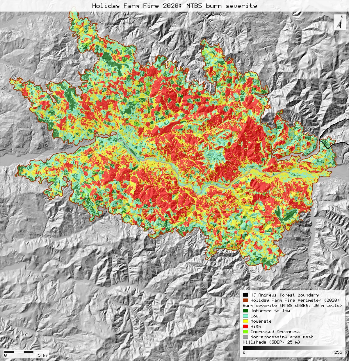
1. Holiday Farm Fire: acres by severity class
| MTBS class | Published (ac) | Cells | NativeGIS (ac) | Difference (ac) |
|---|---|---|---|---|
| Unburned to low | 15,965 | 71,799 | 15,968 | +3 |
| Low | 46,878 | 210,775 | 46,875 | −3 |
| Moderate | 51,287 | 230,612 | 51,287 | 0 |
| High | 57,988 | 260,741 | 57,987 | −1 |
| Increased greenness | 1,431 | 6,435 | 1,431 | 0 |
| Non-processing mask | 842 | 3,784 | 842 | 0 |
| Total | 174,390 | 784,146 | 174,390 | 0 |
Method: cells of the published dNBR6 raster whose centres fall inside the published perimeter [6], counted per class by a reclassify that maps each class to itself [8]. Units: 30 m cells (900 m²) in EPSG:5070, converted at 4,046.8564224 m² per international acre and compared after rounding to the whole acre, as MTBS prints them. n = 784,146 cells. The perimeter's BurnBndAc attribute reads 174,384 ac [5]; the polygon itself measures 174,384 ac [92]. Text pulled from the map PDF in layout order puts 1,431 on the non-processing-mask row and 842 on the total row. In raw order the values run 15,965 / 46,878 / 51,287 / 57,988 / 1,431 / 842, then 174,390, so increased greenness is 1,431 ac and the mask 842 ac. The raster agrees: 6,435 cells of class 5 and 3,784 of class 6.
Re-deriving the class map from dNBR
| Rule for a dNBR value exactly on a threshold | Cells off, outside the mask | Mask cells | Cells matching |
|---|---|---|---|
Goes to the higher class: T(k−1) ≤ dNBR < T(k) [12, 14] | 2,541 | 3,784 | 99.19% |
Goes to the lower class: T(k−1) < dNBR ≤ T(k) [16, 18] | 0 | 3,784 | 99.52% |
Thresholds from the perimeter attributes [5]: IncGreen_T -150 Low_T 40 Mod_T 320 High_T 660 dNBR_offst -4. Cells off are counted by (re-derived class × 10 + published class), so the 3,784 cells MTBS masked (class 6) are counted apart: no dNBR rule can produce them. n = 784,146 cells, compared cell by cell with a raster calculation.
2. How much of the forest burned since 2020
Three footprints of the two fires
| Footprint of the fires | Holiday Farm 2020 | Lookout 2023 | Either fire | Overlap |
|---|---|---|---|---|
| HJ Andrews: "burned ca. 70%" | ≈ 70% | |||
| NIFC final incident perimeters (173,393 ac and 25,754 ac in their own attributes) | 2.3% [59] | 68.2% [63] | 70.5% [66] | 0 ha [67] |
| BAER soil burn severity maps, mapped area | 2.1% [74] | 68.1% [81] | 70.2% | 0 cells [88] |
| MTBS perimeters | 2.3% [24] | 67.4% [26] | 69.7% [28] | 0 ha [29] |
| Contrast, a different measure: BAER low, moderate or high soil burn severity | 1.1% [74] | 62.6% [81] | 63.7% | |
| Contrast: MTBS low, moderate or high severity (actually burned) | 1.3% [37] | 57.0% [48] | 58.4% [52] |
Method: the NIFC WFIGS perimeters (served in EPSG:5070) intersected with the forest boundary in EPSG:5070, unioned and dissolved for "either", intersected for "overlap"; shares of the forest's 6,374 ha. BAER: the 20 m soil burn severity rasters of both fires (EPSG:26910, classes 1 to 4, 15 = not mapped), cells whose centre is inside the boundary counted with 0/1 rasters on each map's own grid; the Holiday Farm raster ends inside the forest, so mapped cells × 400 m² are taken over the boundary's own 6,369 ha. The overlap is the Lookout mapped cells whose centre lies inside the polygonized Holiday Farm mapped area [88]. n = 3,345 and 108,481 mapped BAER cells inside the forest.
MTBS: inside the perimeters, and what actually burned
| Part of the forest | Inside the perimeter (ha) | Share inside the perimeter | Share burned (low to high) | Share burned at high severity |
|---|---|---|---|---|
| HJ Andrews: "burned ca. 70%" | ≈ 70% | |||
| Holiday Farm Fire, 2020 | 148 | 2.3% [24] | 1.3% [37] | 0.04% [38] |
| Lookout Fire, 2023 | 4,294 | 67.4% [26] | 57.0% [48] | 19.2% [50] |
| Either fire | 4,442 | 69.7% [28] | 58.4% [52] | 19.2% [55] |
| Both fires (overlap) | 0 | 0.0% [29] | 0.0% [53] | 0.0% [56] |
Method: the forest boundary reprojected to EPSG:5070 (Albers equal-area), 6,374 ha [23], intersected with each MTBS perimeter; the two parts unioned and dissolved for "either", intersected for "both". Burned area: each fire's dNBR6 cells whose centre is inside its part of the forest, polygonized, dissolved by class, classes 2–4 (or 4 alone) selected, dissolved, then unioned and intersected across the fires. Units: m² in EPSG:5070, shown as hectares and as shares of the forest's 6,374 ha. n = 1,646 cells (Holiday Farm) and 47,725 cells (Lookout) inside the forest. The boundary file's own area attribute (UTM) is 6,369 ha [20].
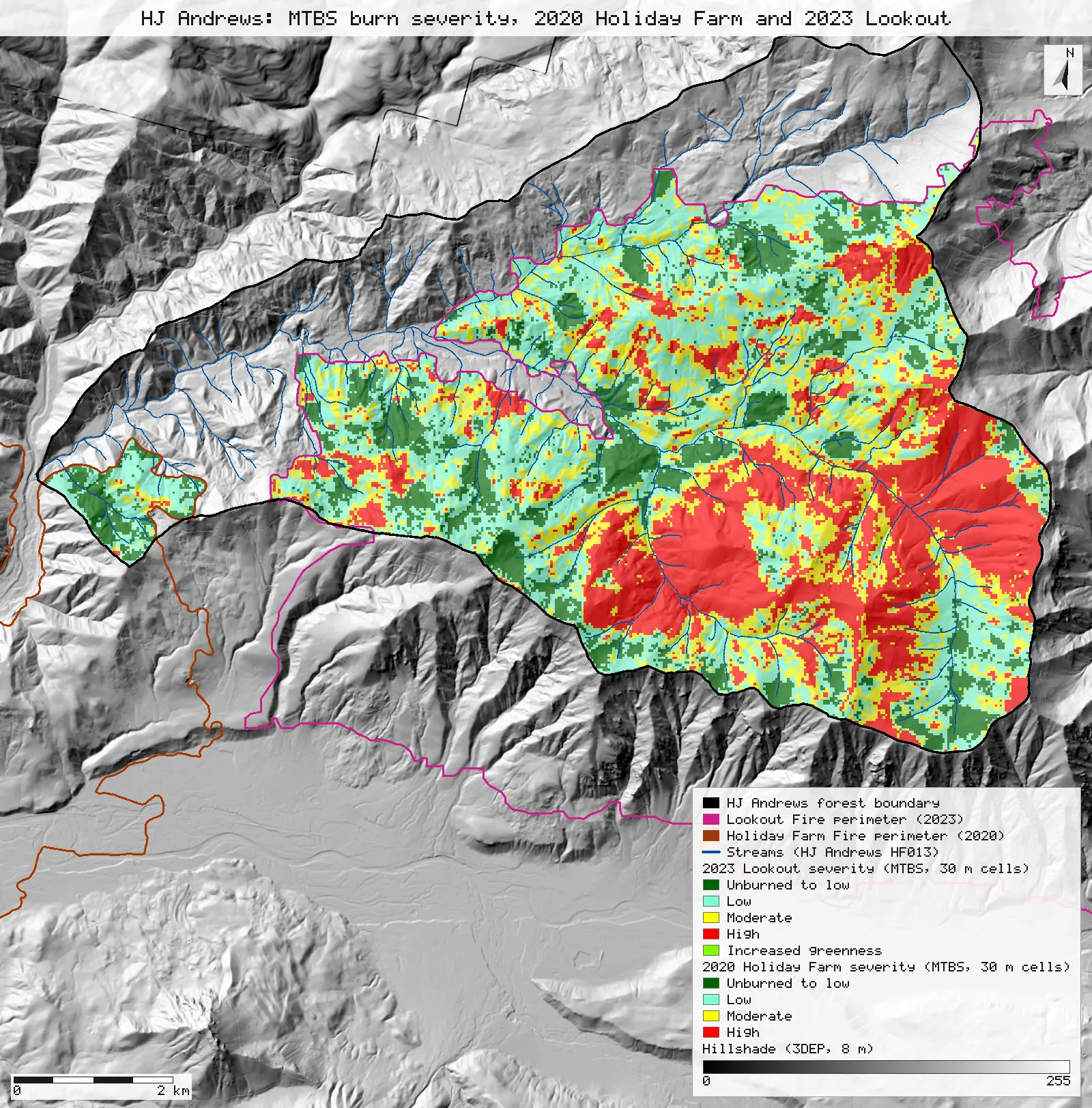
Severity inside the forest, by fire
| MTBS class inside the forest | Holiday Farm 2020 (ha) [34] | Lookout 2023 (ha) [45] | Share of the forest |
|---|---|---|---|
| Unburned to low | 62 | 659 | 11.3% |
| Low | 75 | 1,434 | 23.7% |
| Moderate | 9 | 980 | 15.5% |
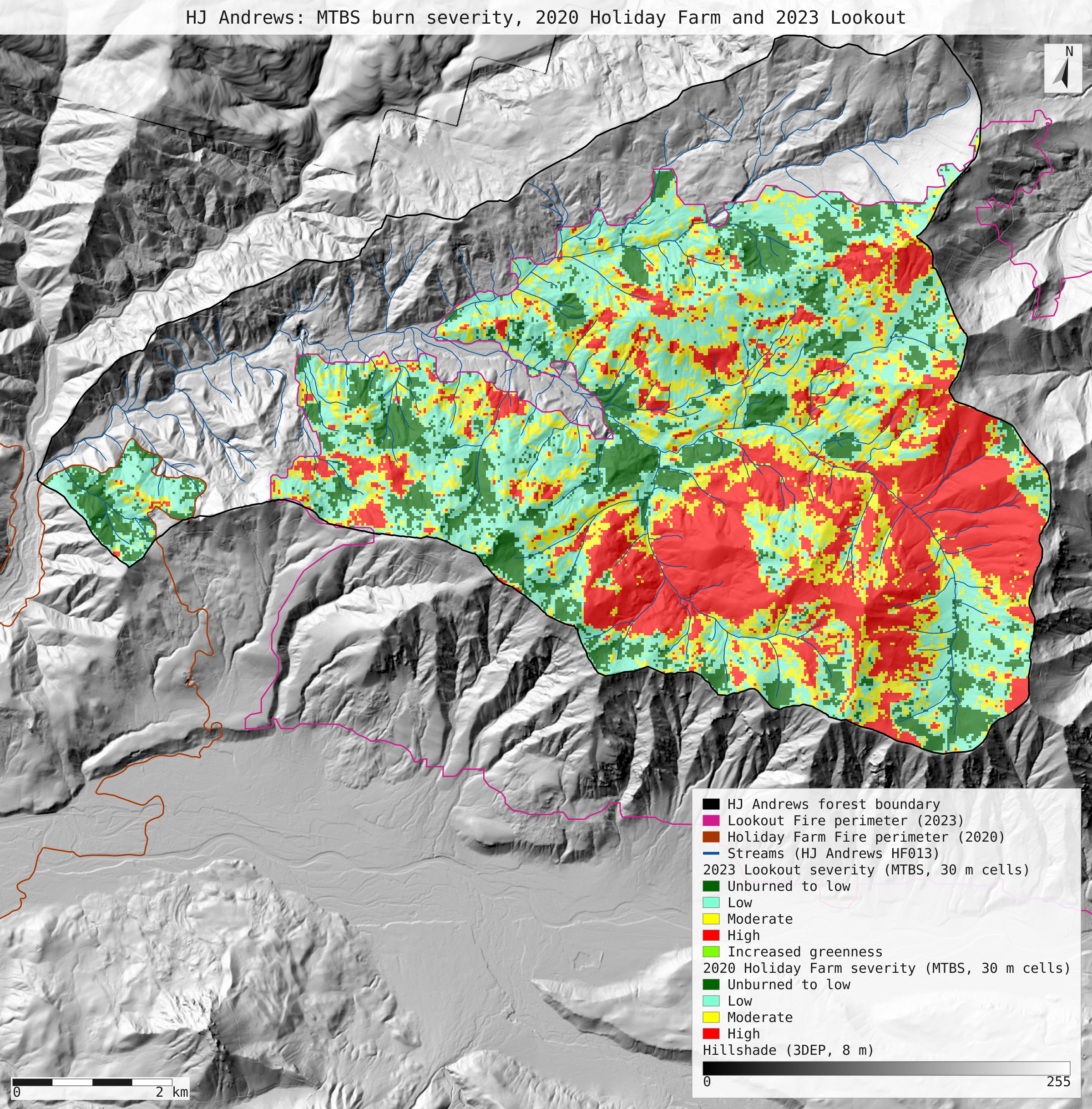
| High | 2 | 1,223 | 19.2% |
| Increased greenness | 0 | 0 | 0.0% |
The two fires do not overlap inside the forest, so their class areas add. Units: hectares from 30 m cells (900 m²).
Why any numbers differ
- The total is exact and three classes match to the acre. 784,146 cells carry a class inside the perimeter, which is 174,390 ac, the published total. Moderate, increased greenness and the non-processing mask match to the acre. High comes to 57,987 ac against 57,988 published: the published classes add up to 174,391, one acre more than the published total, so the table itself carries that acre of rounding.
- Unburned-to-low and low are each 3 acres off, in opposite directions. The published raster has 12 more unburned-to-low cells and 12 fewer low cells than the published table implies. The total is unchanged, so this is not a boundary or clipping difference. The open data cannot say why: the table may have been tallied from a slightly different version of the class map. It is 0.02% of either class.
- The class map follows from dNBR and the thresholds, as in R1. With a value on a threshold going to the lower class, every cell outside the non-processing mask is reproduced. The 3,784 mask cells cannot be re-derived from dNBR: the mask comes from cloud, smoke and missing-data screening, not from the index. With the usual rule (on a threshold goes to the higher class) a further 2,541 cells (0.3%) land one class higher up the dNBR scale than published.
- "Ca. 70%" matches the area the two fires covered. Three footprints agree: 70.5% of the forest lies inside the 2020 or 2023 NIFC final incident perimeter, BAER mapped 70.2% of it, and 69.7% lies inside the MTBS perimeters. The 2020 Holiday Farm Fire reached only the forest's western tip: 2.3% by its NIFC and MTBS perimeters, 2.1% mapped by BAER. Almost all of the 70% is the 2023 Lookout Fire (68.2% NIFC, 68.1% BAER, 67.4% MTBS). The two fires' footprints do not overlap inside the forest in any of the three.
- Not everything inside a footprint burned. Counting only MTBS low, moderate and high severity in either fire, 58% of the forest burned; BAER's low to high soil burn severity classes cover 63.7%. That is a different quantity from the published figure, shown as a contrast, not as a reading of it. 19% burned at high severity by MTBS, nearly all of it in 2023.
Replay it yourself
The run file records every call, its arguments, the checksums of the files it read and the numbers it returned. Replaying it repeats every call in a fresh NativeGIS session and checks that each answer comes out the same.
- Make an empty data folder and fetch the inputs into it exactly as below (bash; the folder layout is the one the run file expects):
cd /path/to/an/empty/folder
mkdir -p samples/holiday-farm && curl -fL -o samples/holiday-farm/HFF_or4417212223120200908.zip https://andrewsforest.oregonstate.edu/sites/default/files/lter/fsdbdata/gis/HFF_or4417212223120200908.zip && unzip -o samples/holiday-farm/HFF_or4417212223120200908.zip -d samples/holiday-farm/x
mkdir -p samples/lookout && curl -fL -o samples/lookout/LF_or4422212214620230806.zip https://andrewsforest.oregonstate.edu/sites/default/files/lter/fsdbdata/gis/LF_or4422212214620230806.zip && unzip -o samples/lookout/LF_or4422212214620230806.zip -d samples/lookout/x
mkdir -p samples/hja-open/gi00601 && curl -fL -o samples/hja-open/gi00601/gi00601.zip https://andrewsforest.oregonstate.edu/sites/default/files/lter/data/studies/spatialdata/gi00601.zip && unzip -o samples/hja-open/gi00601/gi00601.zip -d samples/hja-open/gi00601/x
mkdir -p samples/dem3dep && curl -fL -o samples/dem3dep/hja_forest_5070_8m.tif 'https://elevation.nationalmap.gov/arcgis/rest/services/3DEPElevation/ImageServer/exportImage?bbox=-2066500,2636500,-2052500,2650600&bboxSR=5070&imageSR=5070&size=1750,1763&format=tiff&pixelType=F32&noData=-9999&interpolation=RSP_BilinearInterpolation&compression=None&f=image'
mkdir -p samples/dem3dep && curl -fL -o samples/dem3dep/holiday_farm_5070_25m.tif 'https://elevation.nationalmap.gov/arcgis/rest/services/3DEPElevation/ImageServer/exportImage?bbox=-2107000,2616000,-2062000,2662600&bboxSR=5070&imageSR=5070&size=1800,1864&format=tiff&pixelType=F32&noData=-9999&interpolation=RSP_BilinearInterpolation&compression=None&f=image'
mkdir -p samples/hja-open/hf01301 && curl -fL -o samples/hja-open/hf01301/hf01301.zip https://andrewsforest.oregonstate.edu/sites/default/files/lter/data/studies/spatialdata/hf01301.zip && unzip -o samples/hja-open/hf01301/hf01301.zip -d samples/hja-open/hf01301/x
mkdir -p samples/nifc && curl -fL -o samples/nifc/holiday_farm_2020_wfigs.geojson 'https://services3.arcgis.com/T4QMspbfLg3qTGWY/arcgis/rest/services/WFIGS_Interagency_Perimeters/FeatureServer/0/query?where=attr_UniqueFireIdentifier%3D%272020-ORWIF-200430%27&outFields=OBJECTID,poly_IncidentName,attr_UniqueFireIdentifier,poly_GISAcres,poly_PolygonDateTime&outSR=5070&f=geojson'
mkdir -p samples/nifc && curl -fL -o samples/nifc/lookout_2023_wfigs.geojson 'https://services3.arcgis.com/T4QMspbfLg3qTGWY/arcgis/rest/services/WFIGS_Interagency_Perimeters/FeatureServer/0/query?where=attr_UniqueFireIdentifier%3D%272023-ORWIF-230327%27&outFields=OBJECTID,poly_IncidentName,attr_UniqueFireIdentifier,poly_GISAcres,poly_PolygonDateTime&outSR=5070&f=geojson'
mkdir -p samples/bush-2024/sbs && curl -fL -o samples/bush-2024/sbs/HolidayFarm_SBS_final_export_raw.tif 'https://imagery.geoplatform.gov/iipp/rest/services/Fire_Aviation/USFS_EDW_BAER_SoilBurnSeverityClassification/ImageServer/exportImage?bbox=517347.78446994728,4875154.4185595661,562747.78446994722,4904114.4185595661&bboxSR=26910&imageSR=26910&size=2270,1448&format=tiff&compression=None&pixelType=U8&interpolation=RSP_NearestNeighbor&mosaicRule=%7B%22mosaicMethod%22%3A%22esriMosaicLockRaster%22%2C%22lockRasterIds%22%3A%5B3438%5D%7D&f=image'
mkdir -p samples/baer && curl -fL -o samples/baer/lookout_sbs_export_raw.tif 'https://imagery.geoplatform.gov/iipp/rest/services/Fire_Aviation/USFS_EDW_BAER_SoilBurnSeverityClassification/ImageServer/exportImage?bbox=555218.49909751082,4877231.7363584125,585918.49909751082,4908991.7363584125&bboxSR=26910&imageSR=26910&size=1535,1588&format=tiff&compression=None&pixelType=U8&interpolation=RSP_NearestNeighbor&mosaicRule=%7B%22mosaicMethod%22%3A%22esriMosaicLockRaster%22%2C%22lockRasterIds%22%3A%5B3639%5D%7D&f=image'
- Download run.json (200,747 bytes, sha256
30dd88a3ae9efe96b34a2b031cd3a81050b97a44f7c9e1a7f0f728ccf3dd8f24). - Ask your assistant to replay it with NativeGIS, or call the tool directly:
gis_replay {"action": "replay",
            "file": "<absolute path to the run.json you downloaded>",
            "inputRoot": "<your data folder>",
            "outputRoot": "<a new, empty folder>"}
Paths in the run file are relative to the data folder (inputRoot), and outputs go under outputRoot, so nothing depends on where the original run lived.
Files
- run.json: the recorded run: every call, its arguments and the numbers it returned
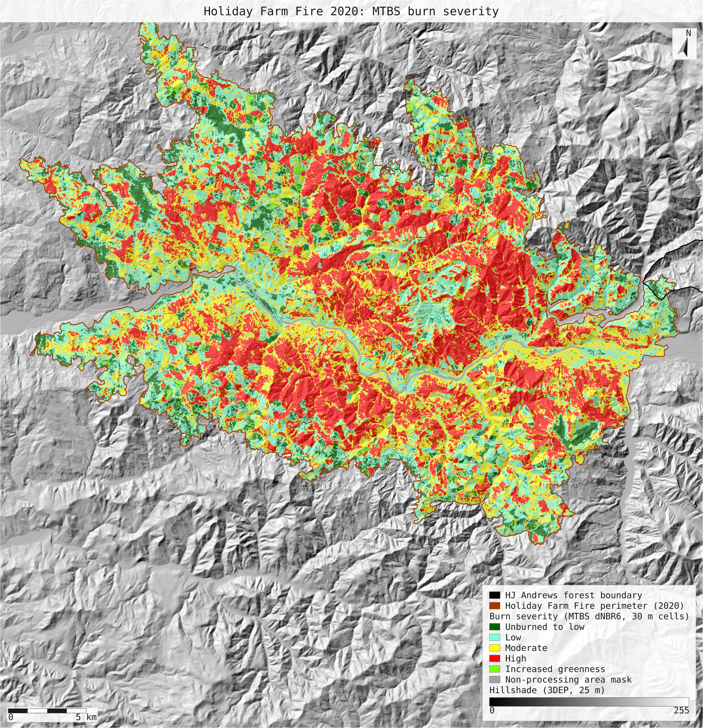
- hff_severity.svg: map: the whole Holiday Farm Fire by MTBS severity class (30 m cells) over a 25 m 3DEP hillshade, with the forest outlined
- hja_severity_both_fires.svg: map: both fires' MTBS severity classes inside the forest (30 m cells) over an 8 m 3DEP hillshade, with streams
Limits
- This checks a published tally, a published classification rule and a rounded outreach figure: open data and arithmetic. It does not test the science. MTBS severity is a satellite index with thresholds chosen by an analyst, and no field plots were used.
- HJ Andrews does not say how its 70% was measured, which boundary or footprint it used, or which fires it counts. Fires since 2020 are taken to be the 2020 Holiday Farm and 2023 Lookout fires, the two MTBS fires HJ Andrews hosts. A smaller fire with no MTBS record would not be counted. Three footprints give 69.7% to 70.5%, so the reading holds whichever was used.
- The NIFC perimeters are the current versions of the polygons in a live service. If one is edited, the download and the shares here would change, and the replay check would show it.
- The MTBS bundles were used as re-hosted by HJ Andrews. The national MTBS downloads were not fetched to confirm the copies are byte-identical.
- The forest's area differs slightly with the projection: 6,369 ha in the boundary file's own attribute (UTM), 6,374 ha measured in equal-area Albers.
- NativeGIS gaps this run hit: the perimeter's CRS had to be declared (the USGS-version Albers .prj is not matched to EPSG:5070); there is no one-call table of area per raster class, so classes were counted with a reclassify that maps each class to itself; dissolving the 36,949 polygonized class regions of the whole fire took over six minutes and blocks the server, so a replay including it ran past the 10-minute request limit and that step was left out of this run.