Lookout Fire 2023 burn severity, acre for acre
Every severity class on the published MTBS acreage table matches to the acre, and the published class map follows cell for cell from the published dNBR and thresholds.
- Total burned area25,103 ac → 25,103 ac 0match
- Unburned to low4,457 ac → 4,457 ac 0match
- Low9,309 ac → 9,309 ac 0match
- Moderate5,576 ac → 5,576 ac 0match
- High5,750 ac → 5,750 ac 0match
[10]
[12]
[21, 22]
Numbers in brackets, like [14], are step numbers in this study's run.json: the NativeGIS call that returned the figure. NativeGIS 0.3.0, recorded 2026-10-31 05:14 UTC.
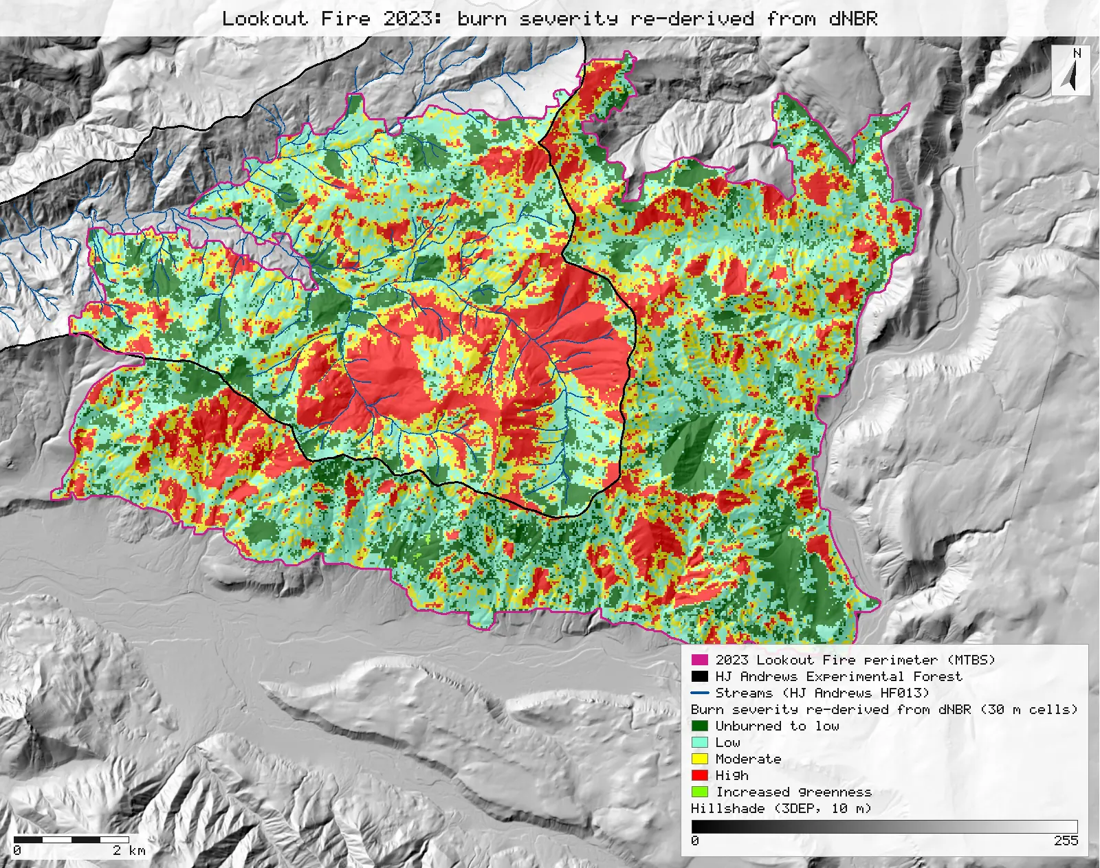
Click or tap a map to open it full screen, then zoom and pan.
What was published
The "Acreage of Burn Severity" table on the MTBS fire map, and the thresholds that make the classes (perimeter attributes IncGreen_T, Low_T, Mod_T, High_T, dNBR_offst).
The data and where it came from
All of it is open: downloaded without an account or a form.
| Data | Where | Licence |
|---|---|---|
| MTBS fire bundle for OR4422212214620230806: dNBR, dNBR6 and RdNBR GeoTIFFs (30 m, USA Contiguous Albers), the burn perimeter shapefile, metadata and the map PDF | Re-hosted by the HJ Andrews LTER, 8.3 MB zip, no form or account https://andrewsforest.oregonstate.edu/sites/default/files/lter/fsdbdata/gis/LF_or4422212214620230806.zip | US federal data, public domain |
| USGS 3DEP elevation, exported as a 10 m DEM (32-bit float GeoTIFF, EPSG:5070) for the Lookout Fire's window; used only for the map's hillshade | USGS National Map 3DEP elevation image service (exportImage), no form or account; two exports gave the same sha256 https://elevation.nationalmap.gov/arcgis/rest/services/3DEPElevation/ImageServer | US federal data, public domain |
| HJ Andrews stream network (HF013, hydro.shp), NAD83 UTM zone 10N; drawn on the map only | HJ Andrews LTER, zip, no form or account https://andrewsforest.oregonstate.edu/sites/default/files/lter/data/studies/spatialdata/hf01301.zip | HJ Andrews data policy (CC BY, acknowledgement requested) |
| HJ Andrews Experimental Forest boundary (GI006, boundary83.shp), NAD83 UTM zone 10N; drawn on the map only | HJ Andrews LTER, 175 kB zip, no form or account https://andrewsforest.oregonstate.edu/sites/default/files/lter/data/studies/spatialdata/gi00601.zip | HJ Andrews data policy (CC BY, acknowledgement requested) |
The input files the run read, pinned by checksum
| File (relative to the data folder) | Bytes | sha256 |
|---|---|---|
samples/lookout/x/or4422212214620230806_20230731_20240826_burn_bndy.shp | 33,644 | 44058cc0c370ce97… |
samples/lookout/x/or4422212214620230806_20230731_20240826_dnbr6.tif | 398,684 | 221e116ff1ab8180… |
samples/lookout/x/or4422212214620230806_20230731_20240826_dnbr.tif | 774,936 | 9bc6bed26d918204… |
samples/dem3dep/lookout_fire_5070_10m.tif | 15,600,684 | 7d491709f433196d… |
samples/hja-open/hf01301/x/hydro.shp | 173,308 | 263271acd998f7bd… |
samples/hja-open/gi00601/x/boundary83.shp | 10,540 | 0774de0a9ebd9693… |
Full checksums are in run.json. Replay refuses an input whose checksum differs.
Method
- Open dnbr6.tif and dnbr.tif (30 m grids, EPSG:5070, metres). The perimeter's .prj is the non-EPSG "USA_Contiguous_Albers_Equal_Area_Conic_USGS_version". NativeGIS does not map that name to an EPSG code, so the perimeter is opened with EPSG:5070 declared. The projection parameters are identical, and nothing is reprojected.
- Read the thresholds and the published total acreage from the perimeter's attributes.
- Clip dNBR6 to the perimeter, keeping cells whose centre is inside it. Polygonize the classes (4-connectivity), dissolve by class, measure the areas and read them back.
- Clip dNBR to the perimeter and reclassify it with the published thresholds twice: first with the usual rule, where a value equal to a threshold goes to the higher class, then with the rule where it goes to the lower class. Compare each result with the published dNBR6, cell by cell.
- Render the map as SVG: the re-derived classes as 30 m cells at 65% opacity over a hillshade of a 10 m USGS 3DEP DEM, with the fire perimeter, the HJ Andrews boundary and its streams. Export the re-derived class raster (COG) and the class areas (GeoPackage).
The run made 32 NativeGIS calls: gis_open × 7, gis_query × 3, gis_process × 18, gis_render × 2, gis_export × 2.
Published numbers next to ours
Acres by severity class
| Class | MTBS (ac) | NativeGIS cells | NativeGIS m² | NativeGIS (ac) | Difference (ac) |
|---|---|---|---|---|---|
| Unburned to low | 4,457 | 20,043 | 18,038,700 | 4,457.46 | 0 |
| Low | 9,309 | 41,858 | 37,672,200 | 9,309.00 | 0 |
| Moderate | 5,576 | 25,073 | 22,565,700 | 5,576.11 | 0 |
| High | 5,750 | 25,855 | 23,269,500 | 5,750.02 | 0 |
| Increased greenness | 11 | 48 | 43,200 | 10.67 | 0 |
| Non-processing mask | 0 | 0 | 0 | 0.00 | 0 |
| Total | 25,103 | 112,877 | 101,589,300 | 25,103.26 | 0 |
Method: cells of the published dNBR6 raster whose centres fall inside the published perimeter, polygonized, dissolved by class and measured [6, 7, 8, 10, 12]. Units: m² from the 30 m grid (900 m² a cell) in EPSG:5070, converted at 4,046.8564224 m² per international acre and compared after rounding to the whole acre, as MTBS prints them. n = 112,877 cells. The perimeter's own BurnBndAc attribute reads 25,103 ac [5].
Text pulled from the map PDF in layout order puts "11" on the non-processing-mask row. In raw order the values run 4,457 / 9,309 / 5,576 / 5,750 / 11 / 0 down the table, so increased greenness is 11 ac and the mask 0. The raster agrees: 48 cells of class 5, none of class 6.
Re-deriving the class map from dNBR
| Rule for a dNBR value exactly on a threshold | Cells matching MTBS dNBR6 | Agreement |
|---|---|---|
Goes to the higher class: T(k−1) ≤ dNBR < T(k) [14, 15] | 112,453 | 99.624% |
Goes to the lower class: T(k−1) < dNBR ≤ T(k) [21, 22] | 112,877 | 100.000% |
Thresholds from the perimeter attributes [5]: IncGreen_T -150 Low_T 74 Mod_T 308 High_T 573 dNBR_offst 0. n = 112,877 cells, compared cell by cell with a raster calculation.
With the higher-class rule, all 424 differing cells land one class up
| Re-derived class | MTBS class | Cells |
|---|---|---|
| Low | Unburned to low | 250 |
| Moderate | Low | 102 |
| High | Moderate | 66 |
| Unburned to low | Increased greenness | 6 |
Cells where the two rules disagree, polygonized, dissolved by transition and measured [16, 17, 18, 19, 20].
Why any numbers differ
- There are none in the table. MTBS counts 30 m cells inside the perimeter, and so does this run. The centre-in-polygon clip keeps the same 112,877 cells that carry a class in the published raster. The total also equals the perimeter's BurnBndAc attribute.
- The one finding is a rule MTBS does not write down. The metadata gives the thresholds but not which class a value exactly on a threshold belongs to. dNBR is stored as whole numbers, so some cells land exactly on a threshold. Put those in the higher class (the usual reading) and 0.4% of cells come out one class too high. Put them in the lower class and the published map is reproduced cell for cell. Anyone re-deriving MTBS classes needs that rule.
Replay it yourself
The run file records every call, its arguments, the checksums of the files it read and the numbers it returned. Replaying it repeats every call in a fresh NativeGIS session and checks that each answer comes out the same.
- Make an empty data folder and fetch the inputs into it exactly as below (bash; the folder layout is the one the run file expects):
cd /path/to/an/empty/folder
mkdir -p samples/lookout && curl -fL -o samples/lookout/LF_or4422212214620230806.zip https://andrewsforest.oregonstate.edu/sites/default/files/lter/fsdbdata/gis/LF_or4422212214620230806.zip && unzip -o samples/lookout/LF_or4422212214620230806.zip -d samples/lookout/x
mkdir -p samples/dem3dep && curl -fL -o samples/dem3dep/lookout_fire_5070_10m.tif 'https://elevation.nationalmap.gov/arcgis/rest/services/3DEPElevation/ImageServer/exportImage?bbox=-2066300,2634800,-2045100,2652200&bboxSR=5070&imageSR=5070&size=2120,1740&format=tiff&pixelType=F32&noData=-9999&interpolation=RSP_BilinearInterpolation&compression=None&f=image'
mkdir -p samples/hja-open/hf01301 && curl -fL -o samples/hja-open/hf01301/hf01301.zip https://andrewsforest.oregonstate.edu/sites/default/files/lter/data/studies/spatialdata/hf01301.zip && unzip -o samples/hja-open/hf01301/hf01301.zip -d samples/hja-open/hf01301/x
mkdir -p samples/hja-open/gi00601 && curl -fL -o samples/hja-open/gi00601/gi00601.zip https://andrewsforest.oregonstate.edu/sites/default/files/lter/data/studies/spatialdata/gi00601.zip && unzip -o samples/hja-open/gi00601/gi00601.zip -d samples/hja-open/gi00601/x
- Download run.json (65,102 bytes, sha256
9d1f0af75d27b57cab3cec335befcc2aa790988a40e5092de5d642a491bfd91a). - Ask your assistant to replay it with NativeGIS, or call the tool directly:
gis_replay {"action": "replay",
            "file": "<absolute path to the run.json you downloaded>",
            "inputRoot": "<your data folder>",
            "outputRoot": "<a new, empty folder>"}
Paths in the run file are relative to the data folder (inputRoot), and outputs go under outputRoot, so nothing depends on where the original run lived.
Files
- run.json: the recorded run: every call, its arguments and the numbers it returned
- COMPARISON.md: the written comparison, with step citations
Limits
- This checks a published tally and a published classification rule: open data and arithmetic. It does not test the science. Whether 74, 308 and 573 are the right severity breaks for these forests was an MTBS analyst's call, and checking it would need field burn-severity plots. None are public for this fire.
- The MTBS bundle was used as re-hosted by HJ Andrews. The national MTBS download was not fetched to confirm the two copies are byte-identical.
- NativeGIS gaps this run hit: the perimeter's CRS had to be declared (NGISB-6); the GeoPackage export writes EPSG:5070 without a WKT definition (NGISB-7); gis_report refuses runs without a point cloud, so no cited report was generated (NGISF-49); there is no one-call table of area per raster class (NGISF-50).